Showing posts with label Hawaiian ahupua'a. Show all posts

Monday, December 22, 2014

Ho'opili Project Is Definition Of Insanity - From Transit System To Really Massive Land Development Scheme

Ho'opili Project Is Definition Of Insanity - From Transit System To Really Massive Land Development Scheme

John Bond,  Kanehili Cultural Hui

You have to really wonder why so many experts in soil science, traffic, farming and three former governors OPPOSED the Ho'opili Project. The main PROPONENT for Ho'opili was Ex-Governor Abercrombie and we all know how popular he became after shoving it forward in 2012 with his pro-developer stacked Land Use Commission panel.

H-1 is already a total nightmare and this project will way OVERBUILD West Oahu adding 12,000 more homes on top of many other large home and land development projects. This will literally create a major environmental DISASTER with completely grid locked traffic. Absolutely everything is BAD about this project because it also paves over West Oahu's best farmland and creates massive polluted water runoff that will be directed either into Pearl Harbor or the offshore reef system.

Just for those who don't know, the REAL NAME for this area is not Ho'opili but instead Honouliuli which was a 1000 year old native Hawaiian food bread basket and traditional cultural place (TCP) supporting the largest Hawaiian population on the island of Oahu.

http://www.stophoopili.com/watch-testimony.html

Honouliuli farm lands are the Golden Triangle of deep rich chocolate brown volcanic soil fed by a multitude of natural freshwater springs from the Waianae mountains. It remains an ideal location for high volume fresh farm vegetables and sustainable agriculture today and covering it with concrete and asphalt will literally be a crime against the public.

All open areas of the Ewa Plain are now being filled in with buildings, concrete and asphalt. All this polluted surface water has to run off through gutters into either the ocean or permanent holding ponds.


Nearly all of the once bountiful ocean resources are
being killed off around the Ewa Plain...It's becoming a huge, polluted, traffic 
choked nightmare with continuous building approvals by City and State government officials.


This last open farmland area will soon be filled in with buildings, asphalt and concrete. When this was sugar cane fields the water naturally percolated back into the karst aquifer.

FTA and HART Failed To Recognize 

Federal Judge Ruling On Rail Route TCP's


Honouliuli Ewa's Makakilo Kalo'i Gulch - A Rare In Depth Survey Of This Important Cultural Property


Honouliuli Ewa TCP's Are Important Wahi Pana (Sacred Places) On Multi-Dimensional Levels


FTA and HART Rail Misrepresent The True Ewa Honouliuli Native Hawaiian Spirit Pathway


West Oahu Residents Speak Out At Important Ag Lands And Hoopili Station Meetings


Ewa Plantation Prime Ag Land Still Retains Centuries Old Traditional Agricultural Features


A Tomb Stone To A 1000 Year Old Native Hawaiian Traditional Cultural Place


Saturday, June 28, 2014

Ewa Plains 1825 Malden Trails - Important Hawaiian Cultural History Still Being Denied

Ewa Plains 1825 Malden Trails - Important Hawaiian Cultural History Being Denied By Developers

by John Bond,  Kanehili Cultural Hui


Hawaiian royal cloak in Bishop Museum from 1825 HMS Blonde expedition to Oahu.

Some of the most important native Hawaiian Trails in the State of Hawaii exist on the Ewa Plains, and are supposed to be protected by a special State Law, but these trails are being regularly bulldozed over and the important archeological sites around them being destroyed.


Published in 1825 was the survey map by Royal Navy Lt. Malden of the HMS Blonde

The ahupua'a of Honouliuli


 The trails identified in published 1825 Royal Navy survey map

The approximate location of the trails today


The trails ran from the important ancient Honouliuli community by West Loch to One'ula Beach, Kualaka'i Beach and by Puu o Kapolei to Kahe Point - Waianae


Parts of the trail network is still there today but unrecognized by developers and the City and State


A trail head at Ewa Village was the reason the Ewa Plantation was located there in 1890's

1990's Tuggles Map done for Navy BRAC of NAS Barbers Point

Close up of Tuggles Map showing trail route


The Pearl Harbor historic trail actually follows the old Oahu Railway line and is NOT the route of the 1825 Malden Trails which led to ancient Kanehili


***********************************************************


Honolulu City Council RESOLUTION 12-172, CD1 (2012) passed unanimously:


URGING THE HAWAII COMMUNITY DEVELOPMENT AUTHORITY AND THE STATE OF HAWAII TO RECOGNIZE AND PRESERVE THE HISTORIC TRAILS OF THE EWA PLAINS.


WHEREAS, the trails in the Ewa Plains area later known as Marine Corps Air Station (MCAS) Ewa and Naval Air Station (NAS) Barbers Point, and today called Kalaeloa as administered by the Hawaii Community Development Authority, are part of the greater Ewa Plains of West Oahu; and

WHEREAS, the Ewa Plains is a massive ancient karst coral reef where ocean meets mountain streams and fresh rain water percolates through porous 100,000 year old coral to spawn freshwater shrimp and one of Hawaii’s most diverse limu varieties; and

WHEREAS, these Ewa Plains trails and their adjacent historic sites provide clues as to how communities were linked socially, economically, and politically; which areas were important in early times, places of commerce, and religion; and where valuable forest or sea resources were once located; and

WHEREAS, these Ewa Plains trails were first identified after Western contact by Lieutenant C.R. Maiden of the Royal Navy in 1825 and became known as the Maiden Trails on the first published Oahu maps; and

WHEREAS, these Ewa Plains trails identified by Maiden became used for ranching and horseback transportation and became an indelible part of West Oahu’s 150 year old Paniolo and Pa’u horseback culture and early Hawaiian Kingdom history of ranches and farms which were the original Western economic settlements of the Ewa Plains; and

WHEREAS, these identified trails became the location where the Ewa Mill and Plantation was established and why the Oahu Railway was extended to this very important trailside agricultural community which allowed sugar cane to become the major economic engine of the Ewa Plains; and

WHEREAS, these Ewa Plains trails in 1925, due to the nearby location of Ewa Mill and the Oahu Railway, became incorporated into the United States (U.S.) Navy development of Ewa Mooring Mast Field as a naval airship mooring site; and

WHEREAS, these trails, springs, and underground karst water transport system later became further documented in State and Federal land surveys and aquifer maps, and in 1941 when the Ewa Mooring Mast Field became a U.S. Marine Corps airbase known as Ewa Field, these walking and horse ranch trails continued to be used by the Marines and Ewa Plantation community for access to the shoreline; and

WHEREAS, after the Japanese air attack on December 7, 1941 and the great expansion of the area into military airports which became MCAS Ewa and NAS Barbers Point during World War II, these trails were important for military training, patrols on foot and mounted Marine Corps horseback security patrols; and

WHEREAS, after the closure of the Marine and Navy airbases, published I 950s maps show the trails on former MCAS Ewa that are still used today by the Barbers Point riding club; and

WHEREAS, these historic horse and foot trails also link with the over 100 year old Oahu Railway right-of-way and Pearl Harbor Historic Trail plan that allows travel by foot, horse or bike from Pearl Harbor to Nanakuli, and which places the Ewa Plains trails as a center junction point and provides access to the Ewa shoreline; and

WHEREAS, an educational feature of these Ewa Plains trails could also be restored karst sinkhole sites along the trailways explaining the ecological system that sustains the iimu, nourishes food sources such as freshwater shrimp and which helps perpetuate Ewa’s offshore fisheries and sustainability; and

WHEREAS, these trails’ could become a cultural, historic, recreational and educational experience of walking, biking or horseback riding over trails featuring native Hawaiian plants, bird and aquatic life, telling cultural histories, explaining geological facts; and

WHEREAS, an Ewa Plains historic trails project could be a community supported endeavor bringing together cultural practitioners, educators, scientists, environmental and veteran organizations in a positive, holistic concept for community education, recreation and restoration; and

WHEREAS, recreational trails in Ewa could qualify for federal National Park Service (NPS) Recreational Trails Program funding,as well as Surface Transportation Program Flexible, Transportation Enhancement, and Congestion Mitigation Air Quality Improvement Program funding and would be consistent with the Oahu Regional Transportation Plan; and

WHEREAS, federal programs such as the NPS Service Battlefield Protection Program have already awarded a $53,000 grant to help define the Ewa Field battlefield as an historic site, and which could include walking trails and points for historic interpretation; and

WHEREAS, federal programs such as the U.S. Fish & Wildlife Service have programs to restore Ewa Plains karst sinkholes and have already demonstrated that native freshwater shrimp can be restocked and flourish in these unique karst sinkhole habitats, providing working environments for education and training; and

WHEREAS, there are many interested individuals from equestrian clubs, biking, recreational groups, schools, colleges and universities, active duty military family and morale, welfare and recreation organizations, that could benefit from and assist in supporting an Ewa Plains trails program; now, therefore,

BE IT RESOLVED by the Council of the City and County of Honolulu that it supports the mapping and identification of historic trails in the Ewa Plains; and

BE IT FURTHER RESOLVED that the Hawaii Community Development Authority, the State of Hawaii, the United States government, and the City and County of Honolulu are urged to participate in the mapping and identification of the Ewa Plains historic trails; and

BE IT FURTHER RESOLVED that the City and County of Honolulu will not expend any monies to provide for the mapping and

BE IT FINALLY RESOLVED that copies of this Resolution be transmitted to the Hawaii Community Development Authority, the Governor, the Department of Hawaiian Homelands, the Office of Hawaiian Affairs, the President of the United States, the Commander of United States Pacific Command, and the Mayor.

DATE OF INTRODUCTION: 2012 (Passed unanimously 2012)

INTRODUCED BY:

Councilman Tom Berg


*************************************************************

Charles Robert Malden (9 August 1797 – 23 May 1855), was a nineteenth-century British naval officer, surveyor and educator. He is the discoverer of Malden Island in the central Pacific, which is named in his honour.


http://en.wikipedia.org/wiki/Charles_Robert_Malden

He passed the examination in the elements of mathematics and the theory of navigation at the Royal Naval Academy on 2–4 September 1816, and became a 1st Lieutenant on 1 September 1818. In eight years of active service as an officer, he served two and a half years in a surveying ship in the Mediterranean (1818–21), one and a half years in a surveying sloop in the English Channel and off the coast of Ireland (1823–24), and one and a half years as Surveyor of the frigate HMS Blonde during a voyage (1824–26) to and from the Hawaiian Islands (then known as the "Sandwich islands").[1] In Hawaii he surveyed harbours which, he noted, were "said not to exist by Captains Cook and Vancouver." On the return voyage he discovered and explored uninhabited Malden Island in the central Pacific on 30 July 1825. After his return he left active service but remained at half pay. He served for several years as hydrographer to King William IV.


Honouliuli Ewa TCP's Are Important Wahi Pana (Sacred Places) On Multi-Dimensional Levels


Honouliuli Ewa's Makakilo Kalo'i Gulch - A Rare In Depth Survey Of This Important Cultural Property


Ewa Plantation Prime Ag Land Still Retains Centuries Old Traditional Agricultural Features

West Oahu Residents Speak Out At Important Ag Lands And Hoopili Station Meetings


FTA and HART Rail Misrepresent The True Ewa Honouliuli Native Hawaiian Spirit Pathway


Tuesday, September 17, 2013

Kalaeloa Fires In Former Barbers Point Naval Air Station Trigger Arson Concerns

Kalaeloa Fires In Former Barbers Point Naval Air Station Trigger Arson Concerns

By Jim Mendoza  KALAELOA, OAHU   Hawaii News Now
 
 
   Ash on the ground and scorched tree limbs litter an acre in Kalaeloa where a brushfire recently burned.

"The disturbing thing is that the fire was quite intense and went up into the trees and burned a lot of these large trees. We're hoping they'll survive," Ewa Beach resident John Bond said.


He said over the past two months brushfires have popped up in several spots in Kalaeloa on property leased by developer Hunt Hawaii.

Hunt chief operating officer Alan Ong said he's aware of three fires.

"The more recent ones seem to be more located in the eastern portion of our land holdings. They range from an acre to something significantly smaller," he said. "There are no structures that have been damaged. It's mostly vacant land."

Bond believes the fires were set on purpose because of the proximity to busy streets.
"We suspect they're just driving by in a car and they've got a cigarette butt or something else they can flick out into the dry grass," he said.


One recent blaze burned near the corner of Hornet Street and Saratoga Avenue, about a block from Barbers Point Elementary School. The entire area was once part of Barbers Point Naval Air Station.
Bond said Navy security patrolled it until October of last year.

"Shortly after that the people got the message that it was okay to do whatever they wanted out here," he said.

Ong said a lot has improved since the company took over the property, but illegal dumping and vandalism are ongoing issues. He's asking the public for help.


"If anybody should drive by and see any kind of suspicious activity or suspect something might be going on, I encourage them to call the police. Dial 911 and report it," he said.

Hunt plans to increase its security patrols, and will meet with federal, state and city officials on Thursday to discuss the recent brushfires.

See new updates or related to this story here:

http://barbers-point.blogspot.com/2013/10/Kalaeloa-Arson-For-Profit.html

http://barbers-point.blogspot.com/2013/09/Big-Ewa-Trees-Dying.html

http://barbers-point.blogspot.com/2013/09/Navy-Homes-Being-Destroyed.html


Thursday, March 14, 2013

BILL 65 Ewa Development Plan Community Amendments

BILL 65 Ewa Development Plan Community Amendments


Ewa Development Plan Amendments Suggested from Previous EDP Community Meetings

 
1.      There should be NO BIOLAB allowed in Ewa under the Ewa Development Plan. The planned Level 3 Bio Lab will work with some of the most dangerous viruses in the world. There should be no deadly diseases brought into Ewa for experimentation on live animals. The proposed Level 3 Bio Lab will be built in very close proximity to a child day-care center and many very large nearby home rental developments and Hawaiian Homelands developments. Beyond them in close proximity are elementary, junior and senior schools with thousands of students.


2.      DHHL DeBartolo Shopping Center Compliance With Ewa Development Plan. The DHHL DeBartolo Shopping Center project, proposed as the second largest in the State of Hawaii with two large hotels and a massive parking structure, needs to be re-examined by DHHL and conformed to the intent of the Ewa Development Plan. Public hearings are needed along with meetings with DHHL administration to encourage compliance with the EDP. The State and City governments should arrange land swaps with DHHL in the central Kapolei business district so that DHHL can achieve their revenue goals while also being in compliance with the EDP.


3.      No desalination plant in EDP. The concept of Hawaiian ahupua'a sustainability and the Konohiki system should be the guiding policy with no desalination plant in the Ewa Development Plan. New development in the Ewa Plains should cease when there is the clear warning that natural aquifer water resources are being maximized. Without a wise guiding water supply policy based upon centuries of observation and knowledge the Ewa Plains are doomed to a future landscape that is vastly over built, over crowded and over polluted with exhausted water resources and ever higher public and private maintenance fees.


4.      Requirement that before any new schools in the Ewa Development Plan can be constructed with air-conditioning that all current schools be provided with air-conditioning first.


5.      Ewa Village Master Plan Needs To Be Completed. Recommend a Special Cultural and Historical Preservation District be established in Kalaeloa / 'Ewa to include: Ewa Field battlefield, the Hawaiian archeological features,  the OR & L Railway, the three (3) 'Ewa Historic Villages (Renton, Tenney and Varona), the plantation Manager's Mansion and the old grave yard and have all of these sites placed on the National Historic Register.


6.      East West connector road-  no Hoopili/Dr Horton development allowed until that road is built first and completed, from Kualaka`i Parkway to Aawa Drive.


7.      The Critical Need To Preserve Top Grade Irrigation Ready Food Sustainability Farmland. The State of Hawaii Department of Agriculture has confirmed that a majority of the Ho'opili lands slated for development are classified as "A" or "B" grade, or "prime" lands under the state's agricultural land grading system.

 
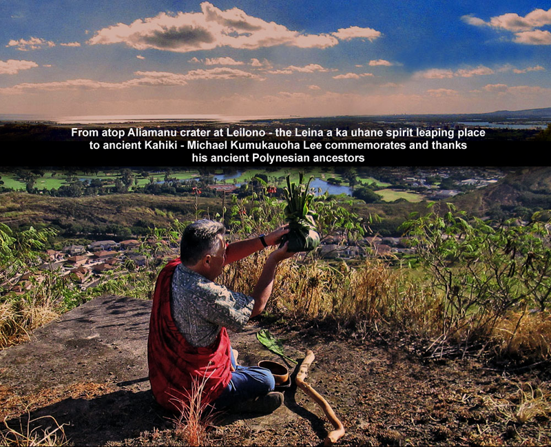
8.      Ewa Historic & Cultural Resources. This area was known as Kanehili and encompasses Hawaiian trails, habitation sites, burial sites and traditional cultural practice areas. Leina a ka Uhane (spiritual leaping off place back to the homeland of Tahiti) – wahi pana (sacred place) which was in the very recent April 2012 HART TCP (Traditional Cultural Place) Survey Report.


9.      Preservation of Special Ewa Plains Historic Heritage Trails. Recognize that there still are very special Ewa Historic Trails, first identified on Western maps in 1825 with coordination with the State of Hawaii “Na Ala Hele” Hawaii Trail and Access Program to begin the geographic information system registration of the Ewa Plains trails into the State’s historic trails inventory.


10.   HCDA Kalaeloa Coordination with City Ewa Development Plan. HCDA should conform to the Ewa Development Plan and not allow Spot Zoning projects which may not be compatible with the adjacent Ewa communities and commerical/industrial areas.


11.   Kapolei Business District. Build the downtown business district in Kapolei proper defined by boundaries of Kalaeloa Boulevard to the west and Ft. Barrett Road to the east parallel between Kapolei Parkway and Farrington Highway.

 
12.   Ewa Plains Karst Water System. The Ewa Plains is composed of a major ancient coral reef Karst fresh water system with important hydrological and geological features that requires special mitigations, as well as possible land development hazards. This Ewa Plains underground Karst water system is documented by the US Geological Survey, US Fish & Wildlife, University of Hawaii’s SOEST and Coastal Geology programs, State Water Board and Honolulu City and County commissioned hydrology studies. Restored Ewa Plains sinkholes have been documented to show that native Hawaiian shrimp will naturally appear without restocking due to the interconnected below ground water flow.


13.   North South Rd. Kualaka`i Parkway should terminate at Roosevelt Road and Coral Sea Road becomes main arterial thoroughfare to the Ewa shore and as second access route for Haseko development.


14.   Move Urban Growth Boundary. Move Urban Growth Boundary south to Mango Tree Blvd  - East to Ft Weaver- and West to Kualaka`i Parkway to ensure preservation of important high quality agricultural lands.


15.   Ewa Transportation. Change from "should" to "shall" in 4.1.6 GENERAL POLICIES. Adequate capacity for peak-hour H-1 freeway commuting is agreed to be Level of Service D.  The H-1 freeway has been at E for years, and will be at F by 2030—with Rail and without Ho’opili.  The ‘Ewa Neighborhood Board approved of changing “should” to “shall” in all of these statements. Provide adequate capacity for major peak-hour commuting to work in the Primary Urban Center. Adequate capacity for major peak-hour commuting shall be the national standard: Level of Service D. (Although the share of residents who will both live and work in Ewa is projected to increase from 17% in 1990 to 44% by 2020, a majority of residents will still commute to jobs outside the region.)

Leilono to Kanehili Kaupe’a - Leina a ka uhane – The Spirit Leaping Place

  KANEHILI CULTURAL HUI Leina a ka uhane – The Spirit Leaping Place of Leilono to Kanehili Kaupe’a Archeological sites in Kanehili have clea...