ANCIENT KANEHILI – Where does this ancient area name come from?
Hi'iaka sister of volcano goddess Pele traveled through Ewa Honouliuli on the ancient trails
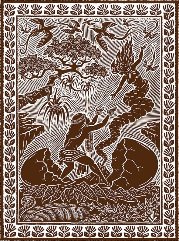
Hi'iaka is the sister of Pele, born in the shape of an egg and was carried from Tahiti to Hawaii by Pele. Her name is often given as Hi'iaka i ka poli o Pele ("Cloud bearer cradled in the bosom of Pele") and was the youngest and favorite sister of Pele among a group of eight sisters. Pele is the goddess of volcanoes, fire, and lightning and is believed to have created the Hawaiian Islands; and is considered to be a sacred, primordial force. Hiʻiaka was the goddess of hula dancers and lived in a grove of Lehua trees which were sacred to her where she spent her days dancing with the forest spirits.
Yet Hiʻiaka would take on dangerous missions for her sister Pele and even get into a big fight over the same lover. This brought Hi’iaka to Oahu in her travels, including “descending along Kanehili,
I am winding along,” which suggests she was likely on a trail which may have been the Kualaka’i trail, which leads to the Spring of Hoakalei.
…Upon finishing her chant, Hiiaka continued down the trail and arrived at Kualakai. At Kualakai, the trail took her to a spring of cool water. Looking into the spring, she saw her reflection shining brightly upon the water’s surface. Hiiaka also saw two lehua trees growing on each side of the spring. Now these two lehua trees were completely covered with blossoms. She then picked the lehua blossoms of these two trees and made garlands for herself.
Hiiaka fashioned four strands to her lei, she then removed the garlands of mao which she had received when descending from Pohakea, and set them aside. She then took the garlands which she had made, and adorned herself with them. Hiiaka then heard the voice calling out from the area of Kanehili:
Hiiaka is the woman
Who picked the flowers of Hoakalei,
And with a needle strung and made them into four garlands,
Because of Hi’iaka’s chants, we today know the names and places of the Honouliuli Ewa Plain and an idea of what the landscape looked like in ancient times:
The wiliwili trees sway, then comes the calm,
The birds of Kanehili endure,
The sun is exceedingly hot on Puuokapolei,
The mao growth is stunted on the seaward plain,
The nohu flowers are like a halakea (kapa) covering
The puaula [young kumu] fish seem to flash along the shores of Kaupea
A companion [is the] Naulu wind,
It is a traveling companion for me.
My man on the many harbored sea of Puuloa,
As seen from the plain of Peekaua,
Let us dwell upon the ohai covered shore,
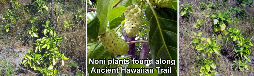
Where the noni blossoms are twisted together,
Descending along Kanehili
I am winding along
These excerpts from the below link offer important details pertaining to wahi pana (sacred places,) traditional and customary practices, and the naming of places visited by Hi‘iaka as she traveled into and across lands of Honouliuli Ahupua‘a. It should be noted also that this tradition is the source of the name “Hoakalei,”
A HAWAIIAN TRADITION OF HIIAKA WHO IS HELD IN THE BOSOM OF PELE
http://www.hoakaleifoundation.org/documents/hawaiian-tradition-hiiaka-who-held-bosom-pele
Connections with Kahiki (ancient homeland) are found in numerous place names, traditional events, and with the beings associated with Ewa Honouliuli. There are several versions of chief Kaha‘i leaving from Kalaeloa for a trip to Kahiki to bring breadfruit back to Ewa (e.g. Kamakau 1991:110). There are several stories that associate places in the region with Kamapua‘a and the Hina family, as well as with Pele’s sisters, all of whom have strong connections with Kahiki (cf. Kamakau 1961:111; Pukui et al. 1974:200).
Its origins are linked to the "return" of Lono, during one of the early migrations, in the form of a mortal man. When the annual Makahiki season closed, Lono went back to the ancestral lands of Kahiki (Tahiti) and Ku returned to be in charge for the growing season.
Although the Makahiki events and activities were not practiced to the same extent as in times past there are said to be those souls who return from the past to remind us of those earlier times. Some old-time residents of these islands can describe hearing the ancient drum beats echoing on particular nights in the vicinities of the temples and sites of the Makahiki celebrations.
Likewise on these nights, there are those who have witnessed spectral apparitions of royal processions of spirits in regalia from an earlier era proceeding along the ancient trails previously used during the Makahiki season.
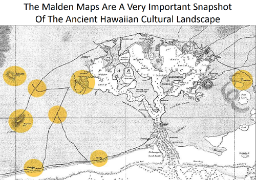
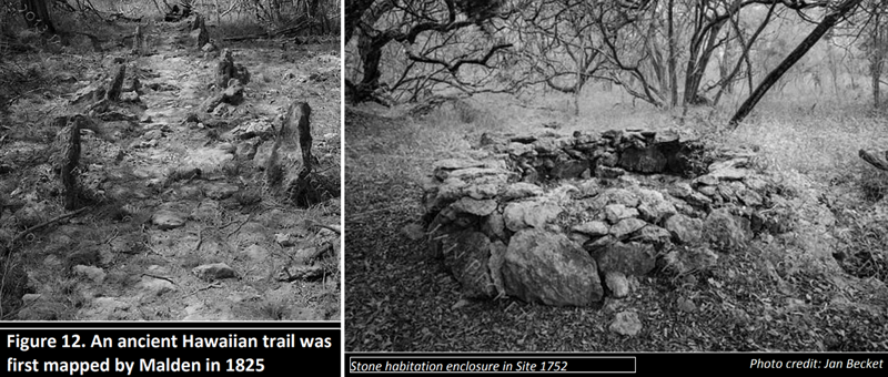
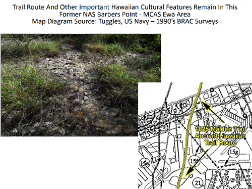
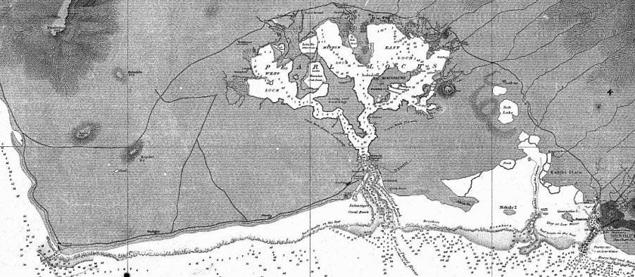
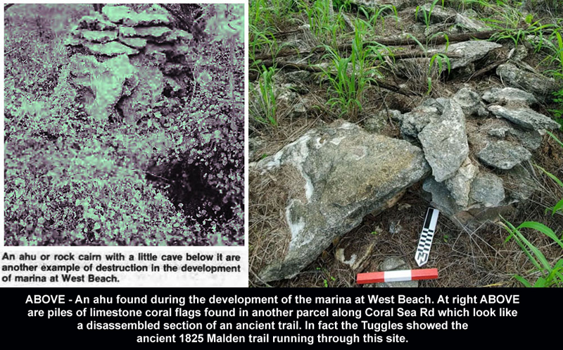
Of enormous help to archeologists trying to figure out why there were so many remaining Hawaiian habitat structures, ahu, heiau and trails were the 1825 Malden trail maps which provided the cultural landscape overview. Most sites were abandoned by the 1820’s.

Ewa Plain Major Hawaiian Burial Place - Federal TCP Documents
http://honouliuli.blogspot.com/2015/07/ewa-plain-major-burial-place.html
Colonial epidemic disease kills most of the Ewa Plain population
https://en.wikipedia.org/wiki/Colonial_epidemic_disease_in_Hawaii

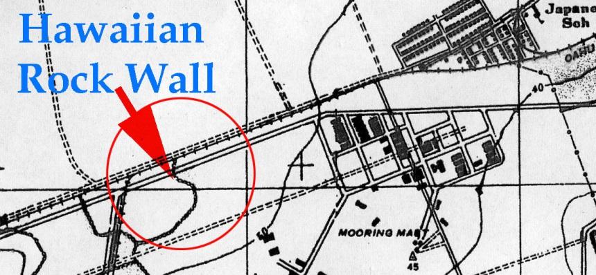
The 1825 Royal Navy Malden maps are an extraordinary snapshot of the ancient native Hawaiian Honouliuli Ewa cultural landscape
The 1995-97 BRAC Navy process required hiring archeological and historic consultants under a major multi-year contract which went through the former air base, which also included the 1952 closed MCAS Ewa, in a somewhat granular way to identify all of the military (1925-1999) sites, prior land uses (cattle ranching, sisal plantation) and all pre western contact native Hawaiian habitation sites and usage.
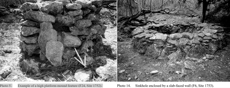
The Phase II BRAC survey documented by Wickler and Tuggle 1997, involved the detailed recording of surface features from five previously recorded sites (Sites 1752-1756) within an area of approximately 59 acres. These sites were organized into two site complexes, Sites 1752 and 1753. Radiocarbon dates indicate that the area was occupied sometime after A.D. 1400, but that intensive settlement did not take place until after about A.D. 1650. The settlements were probably abandoned during the late pre-contact to early post-contact period (1820’s.)
Kalaeloa Heritage Park ʻEwa, Oʻahu
FINAL ENVIRONMENTAL ASSESSMENT September 2014
https://dbedt.hawaii.gov/hcda/files/2014/09/KHP-Final-EA-w-Appendices_to-OEQC.pdf
It was determined that two site complexes, 1752 and 1753, should be officially preserved and eventually they were as the Kalaeloa Heritage Park (KHP) under the administration and protection of a non-profit formed from community members and the local Kapolei Hawaiian Civic club.
Moʻolelo
Hawaiian mo‘olelo (traditions and historical narratives) express native beliefs, customs, practices, and history. Landscapes hold many stories centered on wahi pana (sacred places). In ancient times, each place name was associated with a tradition—ranging from the presence and interactions of the gods with people, documenting an event, or the characteristics of a given place. Oral traditions were passed down through families and recorded in writing in the nineteenth and early twentieth centuries (Maly, 2012). The moʻolelo and wahi pana of the Ewa district and specifically the ahupuaʻa of Honouliuli help situate the archaeological sites of the KHP in a broader cultural and historical context.
A number of moʻolelo related to the ahupuaʻa of Honouliuli are documented by Kepā Maly in “He Mo‘olelo ‘Āina–Traditions and Storied Places In the District of ‘Ewa and Moanalua (In The District of Kona), Island of O‘ahu: A Traditional Cultural Properties Study – Technical Report” prepared for the Honolulu rail transit project (Kumu Pono Associates, 2012). Prior to that report, the Final EIS for the Disposal and Reuse of BPNAS (Navy, 1999) and related Cultural Resource Inventory (Tuggles, 1997) documented many of the cultural and historic resources of the area. The Phase II BRAC survey report by Wickler and Tuggle 1997, specifically documented in detail the future KHP site.
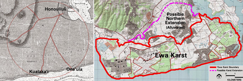
The Ewa Plain is almost entirely an ancient coral limestone reef karst landscape. Most other ancient Hawaiian sites on Oahu were constructed with either rough lava or generally rounded basalt stones, exceptions being Pohukaina near the royal palace. Most people today don’t know the connection between the transformational arrival of the HMS Blonde in 1825 and the Pohukaina karst burial cave.


Pohukaina was a limestone karst cave and its unique history is directly tied to the cultural history of the Ewa Plain and the 1825 HMS Blonde royal navy visit to Puuloa (West Loch) and the surveys creating the 1825 Malden maps. The village of Honouliuli in 1825 was basically the cultural, political and royal capital of Oahu which at that time had a very large Ewa Plain native Hawaiian population connected by trails.
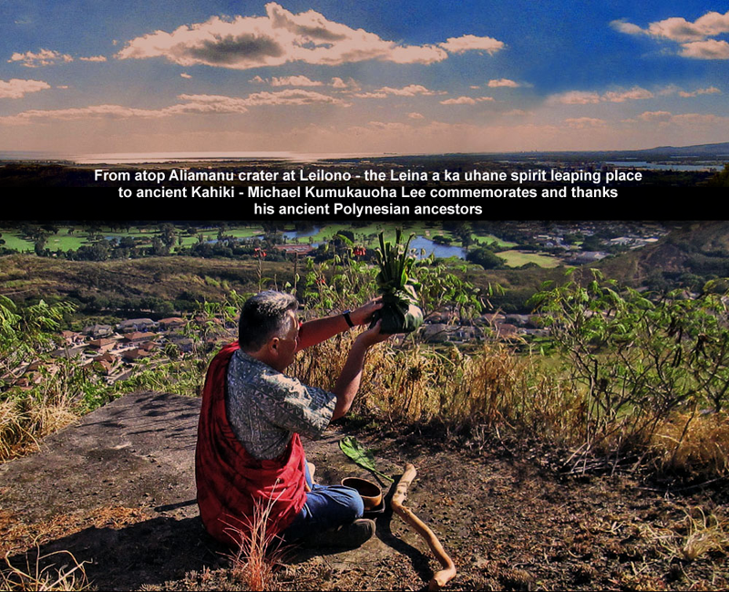
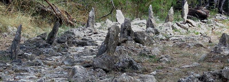
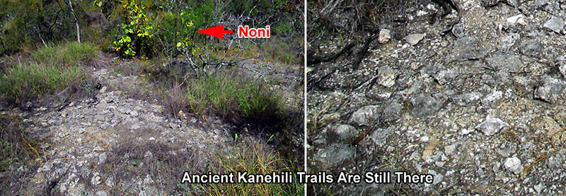
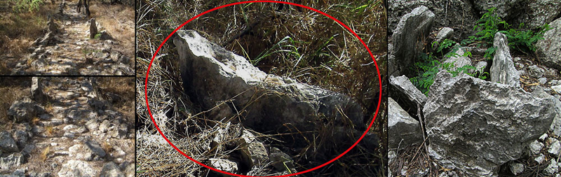
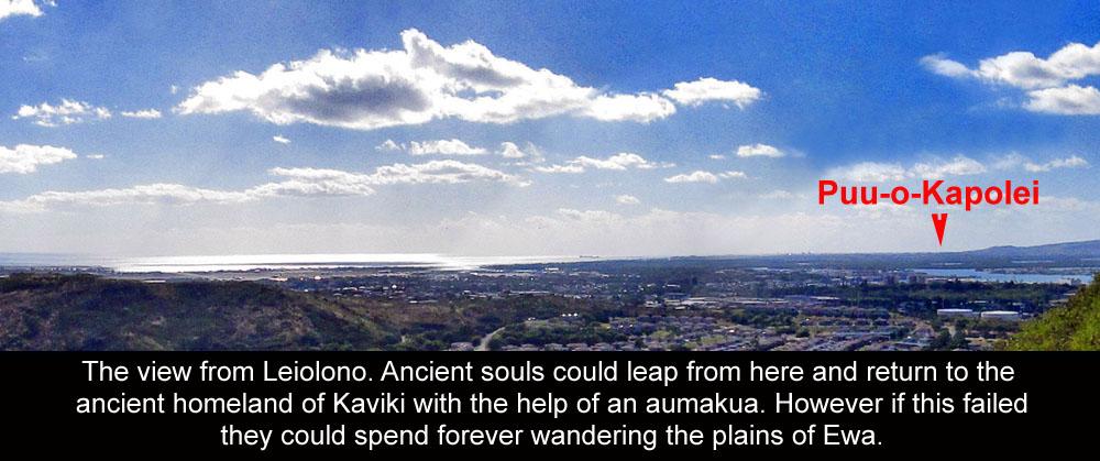
The unique integration of many upright coral slabs in the 1752 and 1753 sites and especially the surviving Kualaka’i trail suggests a Tahitian- Raiatea influence, especially when compared to Taputapuatea marae in Raiatea in French Polynesia. The Kualaka’i trail, also used during the Makahiki season for sacred processions honoring the god Lono, may have likely been designed to also suggest a spiritual pathway back to the ancient Polynesian homeland of Kahiki. The concept of the deceased souls of Ewa natives in the Kepa Maly Kumu Pono documented Leina a ka uhane – Spirit Leaping Place from Leiolono to the homeland of Kahiki further documents this in detail. The Leina a ka uhane was officially recognized as an Ewa Traditional Cultural Place (TCP) – Historic District by the federally funded HART rail project and the area mapped was all within former NASBP-MCAS Ewa (Kalaeloa) ancient Kanehili.
Pohukaina
http://www.pacificworlds.com/nuuanu/native/native3.cfm
Taputapuatea marae
https://en.wikipedia.org/wiki/Taputapuatea_marae

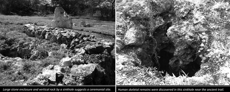
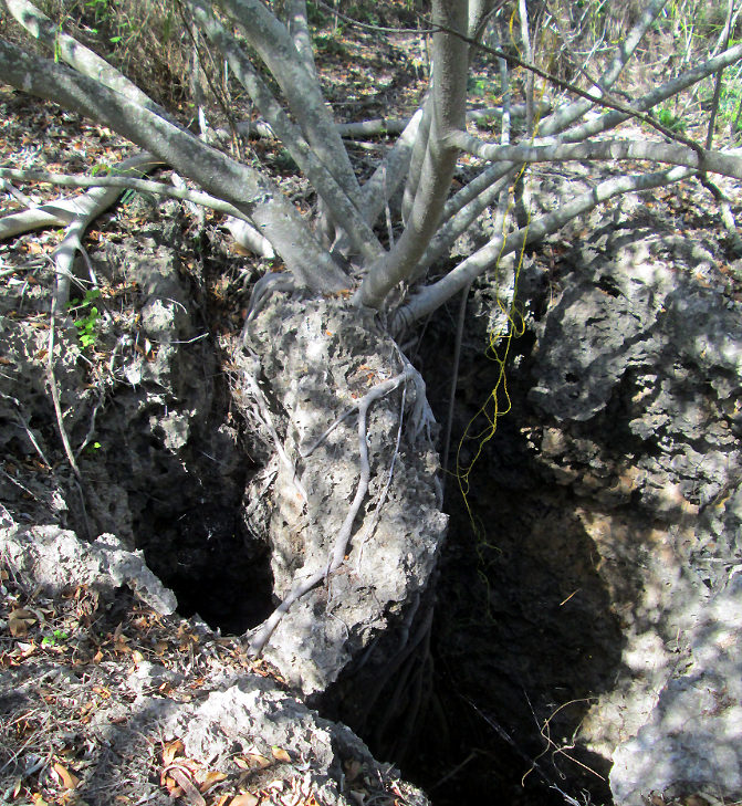
A story associated with the Kualakaʻi coast is about a Tahitian chief named Kahaʻi who appears in genealogy as the son of Hoʻokamaliʻi and grandson of Moʻikeha. Kahaʻi is commissioned to go to Tahiti to retrieve a ʻulu (breadfruit) tree, but travels beyond Tahiti to Samoa to get the ulu tree and bring it to the Ewa-Kanehili-Puuloa area where he plants it. Due to the overall dry karst Ewa plain it seems likely that this first ulu was planted in a large sinkhole in or very near the subterranean fresh mountain spring water which was very abundant in ancient times. Ancient Ewa sinkholes could actually be extremely large and deep, enough to cultivate a significant crop of plants and food. Numerous Ewa resident oral histories report very large sinkholes and sea caves throughout the Ewa Beach area before most of these were bulldozed and filled in by land developers. Early 1925 air photos also show many in Ewa which were spring water and agricultural resources for ancient Hawaiians likely all connected by trails.
Evidence Of Large Karst Sinkholes In Ewa Gentry Community Properties
https://ewa-hawaii-karst.blogspot.com/2014/12/large-karst-sinkholes-in-Ewa.html
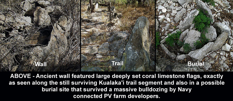
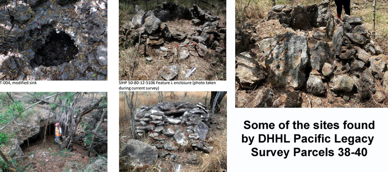
Sites 1752 and 1753, which became incorporated into the Kalaeloa Heritage Park on property transferred to the State agency HCDA after the Navy BRAC, contains a variety of Hawaiian habitation structures, agricultural features, mounds modified sinkholes and some human burials. Of particular note is the trail paved with limestone karst slabs and bordered by parallel rock alignments with pairs at regular intervals. The intact portion of the ancient trail is over 300 meters (985 feet) in extent, going mauka-makai (seaward-inland.) This is most likely the surviving segment of one of the major trails of the ʻEwa Plain, as recorded by surveyor Lt. Charles Malden, Royal Navy in 1825.
Charles Robert Malden
https://en.wikipedia.org/wiki/Charles_Robert_Malden
The ancient Hawaiian trails map is a key “snapshot” of the earliest documented historical features of the Ewa Plain and in this particular area that was known as Kanehili, generally containing NASBP and MCAS Ewa. Kanehili was an “ili” (district) below the larger Kaupe’a plain where trails ran to the royal political and cultural capital of Honouliuli, up mountain trails and over to Pu’u-o-Kapolei, a very important heiau.
Pu'u-o-Kapolei was the home of the Kamapua'a family, and a sacred place associated with the setting sun and likely where the star cluster Makali'i (Pleiades) would be sighted beginning the Makahiki. The sun peaking just over Pu'u-o-Kapolei was an important seasonal signal that could be seen on Oahu as far away as today’s Waikiki beach. These seasonal changes affected fishing, agriculture and other important social customs including kapus. The sun, moon and stars were the ancient Hawaiian internet and they provided lots of information including future predictions as seen by kahuna at Pu'u Makakilo.
The Pele family is amongst the Tahitian ancestors of Native Hawaiians and it was Hi’iaka, Pele’s sister, in her famous travels and chants that provided the geographic names and approximate locations of these Ewa Plain sites. Hi’iaka and the 1825 Malden trail maps were extremely helpful in linking together all of the archeological sites, place names and threads of collected stories, including from old Hawaiian language newspapers, so that the Honouliuli Ewa Kanehili Cultural Landscape could be understood and interpreted today. Ethnographer Kepa Maly - Kumupono provided significant research and cultural history of the Ewa Plain under contracts with the Navy BRAC and HART Rail projects.
The Wickler-Tuggles study identified within Site 1753, a men’s house, and a scattering of residential structures that entail cooking, sleeping areas, and some tool production. The community’s local agricultural component is represented by the cultivation features that surround the residential cluster. It is possible that the religious structures at Site 1752 may have served the general area, including the community at Site 1753. These sites appear to have had a somewhat less rigid social hierarchy and might be considered as the Honouliuli center suburban communities involved in fishing, agriculture and specialized bird feather collection, particularly the O’o and Mamo species with bright yellow plumage.

Most of the KHP was relatively undisturbed because it was a military buffer zone between the Naval Air Station and former MCAS Ewa, which was divided by Coral Sea Road. Remaining cultural sites within the KHP include a rectangular permanent habitation structure, L-shaped temporary enclosures, the ancient trail, sinkholes used for agriculture and water supply, sinkholes used for burials and heiau, and a burial ahu (altar, shrine, or cairn.) Recent archeological surveys have found much more than what is in KHP.
The KHP, by way of the Kualaka’i trail is also linked to the important place of Kualaka'i, an ancient village where a small community still existed prior to WW-II and all the area taken over as a major military base. Oral histories prior to this describe the Kualaka’i coast area as a rich, bountiful fishing area that could sustain a large population living along the coast with the interior linked by the major trails to agricultural sites including many freshwater spring irrigated kalo lo’i (Taro patches) in Honouliuli.

The dominance of fish and marine shell in KHP sites 1752 and 1753 midden (refuse dumps) coupled with an emphasis on fishing gear and related manufacturing tools and waste material demonstrates that marine resources played an important role in the diet of residents. This importance is further emphasized by the presence of at least two fishing shrines and by the possible use of numerous fish drying platforms. During the Makahiki season some of these products would be given as taxes to ali’i.
Cultivation was also an important part of the economy, given the numerous agricultural features in the survey area. There are also two structures that may have been agricultural heiau. The identification of economically important Polynesian-introduced plant taxa such as ti, ipu (gourd), kukui (candlenut), ʻulu (breadfruit), and kou in the cultural deposits suggests these species grew or were cultivated in the sites. Areas outside of KHP along Coral Sea Rd also have trails, rare native plants, and large Ti growing in sinkholes.

Origins of ʻulu in Hawaii
A significant mo‘olelo tells of the origin of the ʻulu, or breadfruit, in ʻEwa as one of the first two places in
Hawaiʻi. The breadfruit of Pu‘uloa-Kualaka’i-Kanehili came from the mythical land of Kahiki, named Kanehunamoku. The first Ewa Puuloa settlers were believed to have landed at ‘Ewa Beach near Pu‘uloa (Beckwith 1970:343).Two men of Ewa Pu‘uloa out fishing got caught in a major storm and landed on an island only inhabited by the gods who introduced them to the fruit of the ʻulu tree which they carried back home with them. Other stories say that early Polynesian settlers to Ewa brought ulu with them.
The ʻulu tree in Polynesian culture represents rebirth or new life. The breadfruit (ʻulu) is associated with Kualakaʻi, where the spring of Hoakalei is located. Kanehili Cultural Hui believes they found the actual location of this spring based upon maps, descriptions and ground reconnaissance in Kualaka’i – Kanehili.
Hi'iaka, Goddess Sister of Pele - Visits The Spring of Hoakalei, Site Which Still Exists Today
https://www.youtube.com/watch?v=vr9BK2IdSgs This area should be a National Register site.
Gathering for Plant Resources
Archaeological surveys identified ʻuala (sweet potato) mounds in the KHP area and that sweet potato was an important food crop for Hawaiians living along the ancient trails where it was more difficult to have lo’I (taro) patches. In a moʻolelo, the chief Maweki who is referred to as Tahitian is responsible for bringing ʻuala (making reference to blue poi) from South America to Honouliuli. Sweet potato came from South America and is not Polynesian. Reportedly sweet potato was first brought to ʻEwa and then introduced to the other islands. Kalo lo’I (taro patches) were located in the rich volcanic soil uplands of the Waianae volcano and especially around the wet Honouliuli lowlands inside Puuloa (West Loch.)
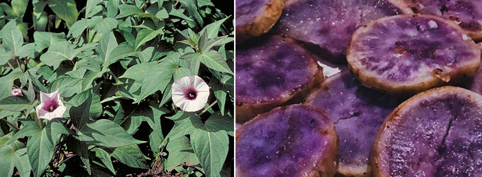
Recent evidence suggests that ancient Polynesian seafarers likely interacted with people in South America long before the Europeans set foot on the continent. The findings, published in the Proceedings of the National Academy of Sciences, offer more evidence that the Polynesians probably introduced it to Ewa in 1100 A.D. (red), while the Spanish (blue) and Portuguese (yellow) brought other sweet potato varieties from the Americas around 1500.
"There's been many kinds of evidence – linguistic and archaeological – for contact between these two people," Caroline Rouiller, an evolutionary biologist at the Center for Functional and Evolutionary Ecology in France who led the study. "There's a lot of evidence accumulating over the last 10 years that the Polynesians made landfall in South America.” “They had sophisticated, double-hulled canoes — like very large catamarans — which could carry 80 or more people and could be out to sea for months."
How The Sweet Potato Crossed The Pacific Way Before The Europeans Did : The Salt : NPR
The Tradition of Kana
Hawaiian historian (1815 –1876) Samuel M. Kamakau’s submittals to the Hawaiian newspaper Kuokoa provide details on wahi pana (sacred places) of the Ewa District. Kamakau cites the tradition of Kana, recording the names of certain chiefly and priestly ancestors who came from Kahiki, and who were the founders of lineages tied to various ahupua‘a in the ‘Ewa District. This is the reason Kamakau refers to Ewa as “the celebrated lands of our ancestors''. The upright stones found in the cultural sites on the Ewa Plain also echo the Tahiti- Raiatea style of construction at the Taputapuatea marae, a highly sacred religious site associated with canoe voyaging, governance, and Eastern Polynesian chiefly lineages.
After the end of the second period of Polynesian migration, which ethnologist Abraham Fornander (1812 –1887) placed between the 12th and 13th centuries A.D., the ancestors of the Hawaiian people entered into a period of isolation during which the memory of their southern Pacific origins receded further into the past. The concept of Kahiki is echoed in many Pacific cultures and is prevalent throughout Polynesia. The Kualaka’i trail was meant to be a reminder of the sacred Kahiki homeland.
In Hawaiian cultural memory, they began to call their ancient homeland Kahiki honua kele or Kahiki, the land that moved away. To reach it, one had to breach the wall of the ocean horizon, beyond which lay the confines of Kahiki or Kukulu o Kahiki. There were the foreign gods, like Kane and Kanaloa, and the god-like, with whom the Hawaiians felt they shared a common nature. This concept also explains why when Captain James Cook first arrived on the Big Island of Hawaii he and his crew were believed to have come from Kahiki, and that these foreigners must be gods in their magnificent ships. Unfortunately this led to Cook’s death on February 14, 1779. https://en.wikipedia.org/wiki/Death_of_James_Cook

Leiolono, the spirit leaping place for the soul to return back to the ancient homeland of Kahiki
Radiocarbon dates indicate that the 1752 and 1753 KHP area was occupied sometime after A.D. 1400, but that intensive settlement did not take place until about A.D. 1650. The settlements were probably abandoned during the late pre-contact to early post-contact period (1820’s,) due to many Ewa Plain Hawaiian deaths from Western diseases. This eventually led by then to the largely depopulated 41,000 acres of Ewa Plain being acquired for a huge cattle ranch by land developer James Campbell.
https://en.wikipedia.org/wiki/James_Campbell_(industrialist)
The KHP isn’t the only area where ancient Hawaiian trails can be found. There are more trails, significant habitation sites on either side of Coral Sea Road, including large sinkholes and caves.

The Native Hawaiian Cultural Landscape of the 1825 Malden Trails
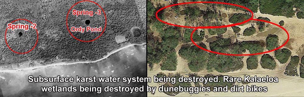
The Honolulu City Council passed unanimously in 2012 the Ewa Plain Trails resolution giving cultural practice further standing in Honouliuli by advocating for the protection of the 1825 Malden Trails (ancient Hawaiian trails) and Ewa Karst water system which is an ancient limestone reef wetlands water system recognized under the Federal EPA Clean Water Act.
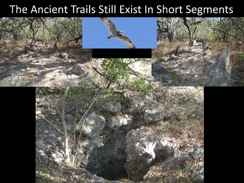
The trails are still there however now only a few are very obvious. The rest of them still there however have less easily defining markers because the early sisal plantation and cattle ranchers used the vertical coral limestone slabs to make fence walls. The way to detect them is to look for other surface features such as coral paving and occasional surviving coral flags. Rare native plants and karst water holes supplied water to the native inhabitants and trail walkers. A Pacific Legacy 2011 archeology study for the DHHL Ka Makana mall stated that the ancient trails were likely still there under more recent construction or naturally accumulated dirt.

A recent Pacific Legacy (2018) DHHL project survey found ancient new trails, a large Makahiki site and many large and deep sinkholes and caves over a large area of ancient Kanehili on the east side of Coral Sea Road.
The trails were actively used by native Hawaiians up until the 1820’s when the large population began rapidly dying from introduced Western diseases. However they were still continuously used by local Ewa plantation residents, Honolulu OR&L railway day trippers (using old sisal station and rail siding flag stops) and coastal camping fishermen right up until Dec 7, 1941 when the beginning of WW-II changed everything and the trails were no longer publicly accessible.
Because the entire area of what is today called “Kalaeloa” (which was never its original name) saw nearly 60 years of closed access by the military along with Coral Sea Rd constructed which ran directly through the same mauka-makai ancient trailway routes. Entire generations of local residents lost cultural contact with the trails. Eventually local residents with military jobs and ID access went to the Ewa shoreline in vehicles, not by walking down the trails which had become overgrown and which lost their original pre-war utility and ancient purpose.
One main trail was to Kualaka’i, which was an ancient fishing village that survived up until the area was closed to build NAS Barbers Point airfield. The remaining Kualaka’i coast was renamed Nimitz Beach and the once large sand dunes, beachfront and interior wetlands to the east became White Plains Beach. Further east to where the Haseko development is today there was a separate trail to One’ula, another important fishing and limu gathering area. The Ewa Mooring Mast Field and later MCAS Ewa was actually constructed intentionally between the two major trials which actually saved parts of them, including ancient Hawaiian sites. Unlike today, 1930’s trained local Hawaii engineers were knowledgeable about the cultural history of the Ewa Plain and trail ways and did what they could to construct around them when possible.
After the closing of the naval air station in 1999, much of the large former base went through a congressional BRAC – Base Realignment and Closure process which handed out parcels to various City and State agencies, many of which are still pending decades later. Many regard the NASBP-Kalaeloa BRAC land parcel divisions as the worst possible and very incoherent.

The concept of Kahiki, the ancestral homeland for Kānaka Maoli (Hawaiians.) Kahiki is the symbol of ancestral connection to ancient Polynesia. The Kualaka’i trail in ancient Kanehili may have been constructed to be a formalized link to the concept of an ocean universe. When used during the Makahiki season it would remind a procession of marchers that they were connected to their ancient homeland.
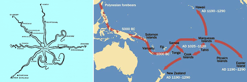
KEALAIKAHIKI - Raʻiātea, whose ancient name is Havaiʻi
The Hawaiian cultural identity is from a Polynesian heritage shaped by the oceanic universe, Moananuiākea. Understanding Hawaiʻi’s connections to the greater Pacific world was fundamental for Hawaiians. The pathway to the motherland, place of origin, to Kahiki.
https://kaiwakiloumoku.ksbe.edu/kealaikahiki
Ke-ala-i-kahiki, the Pathway To Kahiki, “Kahiki Homeland” is the reference to the lands that Hawaiian ancestors migrated from and sailed back to on return visits. Hawaiian culture also shares a strong cultural affinity with the Society Islands, the Tuamotu Archipelago, and the Marquesas Islands.
Raʻiātea, whose ancient name is Havaiʻi, is the location of Taputapuātea Marae, a highly sacred religious site associated with voyaging, governance, and Polynesian chiefly lineages. The heʻe/feʻe (octopus) is a metaphor for Raʻiātea as the center of a cultural alliance consisting of island groups that are under the influence of its radiating tentacles — the northernmost extremity being Hawaiʻi.
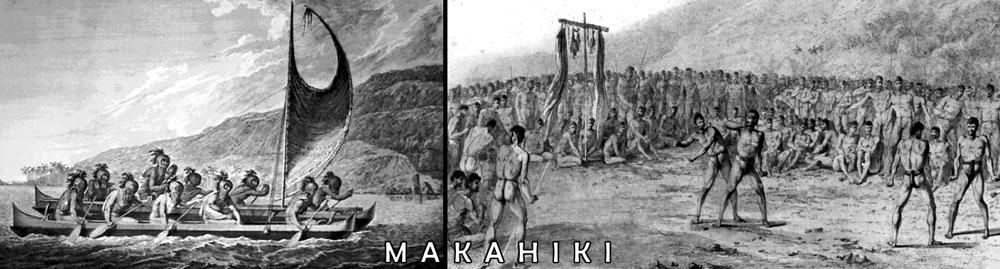
MAKAHIKI – the ancient trails played an very important part
The Makahiki season is the ancient Hawaiian New Year festival, in honor of the god Lono in the ancient Hawaiian religion. In a western context this would be the months of Halloween, Thanksgiving, Christmas and New Years. In Hawaiian religion, the god Lono is associated with fertility, agriculture, rainfall, music and peace. In one of the many Hawaiian stories of Lono, he is a fertility and music god who descended to Earth on a rainbow to marry Laka. In agricultural and planting traditions, Lono was identified with rain and food plants. He was one of the four gods (with Kū, Kāne, and Kāne's twin brother Kanaloa) who existed before the world was created. In his honor, the great annual festival of the Makahiki was held. During this period (from October through February), war and unnecessary work was kapu (forbidden).

The beginning of Makahiki generally is fixed each year by astronomical observations. In Hawaii when Makaliʻi (Pleiades star cluster) rises shortly after sunset, usually on November 17, the rising of the following first crescent moon marks the beginning of the season. On Oahu, it may begin when Makaliʻi rises above Puʻu-o-Kapolei or when the star ʻAʻa (Sirius) appears in conjunction with a particular landform high on a cliff. It depended on local island geographical landmarks.
Makahiki is a holiday covering four consecutive lunar months, approximately from October or November through February or March. The focus of this festive season was a time for men, women and chiefs to rest, strengthen the body, and have great feasts of commemoration (ʻahaʻaina hoʻomanaʻo.) During Makahiki season labor was prohibited and there were days for resting and feasting. The Hawaiians gave thanks to the god Lonoikamakahiki for his care. He brought life, blessings, peace and victory to the land.
In recent years interest has grown again to stage Makahiki trail processions and reenactments as a way to help promote and sustain interest in ancient Hawaiian culture.
In antiquity, many religious ceremonies occurred during this period. Commoners stopped work, made offerings to the chief or aliʻi, and then spent their time practicing sports, feasting, dancing and renewing communal bonds. During the four lunar months of the Makahiki season warfare was forbidden which was used as "a ritually inscribed means to assure that nothing would adversely affect the new crops."

Today, Makahiki events are a way to involve non-Hawaiians in an important seasonal cultural tradition
Three phases of the Makahiki festival
The Makahiki festival was celebrated in three phases. The first phase was a time of spiritual cleansing and making hoʻokupu, offerings to the gods. The Konohiki, a class of chiefs that managed land, provided the service of tax collectors, collected agricultural and aqua-cultural products such as pigs, taro, sweet potatoes, dry fish, kapa and mats. Some offerings were in the form of forest products such as feathers. Some were offered on the altars of Lono at heiau (temples) in each district around the island. Offerings were also made at the local ahu (limestone altars) set up at the boundary lines of each community.
The paved and vertical karst slabs of the ancient trails of Kanehili facilitated the Makahiki processions honoring the god Lono and served as a sacred link back to the Polynesian homeland
THE GODS OF MAKAHIKI – the sacred ceremonial trails were reminders of Kahiki
Lono-i-ka-makahiki or Lono is the main god associated with the Makahiki. Hawaiian tradition tells that Lono travels from Kahiki (ancient homeland) to the Hawaiian Islands when it first rains during the ho‘oilo (wet season) for Makahiki. On the Ewa Plain, rains in the Waianae volcano uplands would soon bring more fresh water cascading through subterranean waterways and springing forth in deep sinkholes and caves. This told everyone that Lono had arrived and was giving precious fresh water to the people.

HO‘OKUPU
The maka‘āinana considered the ho‘okupu (offerings) given during Makahiki as a sort of spiritual cleansing. During the time of Kamehameha I, who united the Hawaiian Islands, ho‘okupu served as a tax to run the Hawaiian Kingdom. Offerings consisted of the best pua‘a (pigs), kalo (taro), ‘uala (sweet potatoes), hulu (feathers), moena (woven mats), and kapa (Hawaiian barkcloth). The offerings would then be distributed between the ali‘i, kahuna (priests), and other favorites of the ali‘i.
AKUA POKO and AKUA LOA
At the time of Kamehameha I, the people observed the tradition called hānaipū or the feeding of Lono. During hānaipū the priests circulated the Islands with poles that represented the Makahiki gods. There were two types of poles: akua loa (long pole representing male gods) and akua poko (short pole representing the female gods). The akua loa features a statue of Lono, and is decorated with pala fern (Marattia douglasii) and white kapa. Priests traveled the islands clockwise for 23 days with the akua loa, visiting ahupua‘a (ancient Hawaiian land divisions). Priests with the akua poko only visited certain areas of the islands.
CLOSING CEREMONY
At the close of Makahiki, an ali‘i impersonating Lono would take a canoe out to sea and return to shore to participate in a mock battle. Men would throw spears at the ali‘i, which he had to dodge in order to prove his divinity. If he survived this task, someone touched a spear to his chest signifying the ritual death of Lono. The ali‘i would then sacrifice a pig in honor of Lono and a wa‘a ‘auhau (tribute canoe) was loaded with offerings and set adrift to return to the mystical land of Kahiki with Lono. This signified the end of Makahiki.
Makahiki - Haleakalā National Park (U.S. National Park Service) (nps.gov)
https://en.wikipedia.org/wiki/Lono
2011 archeology survey report: ancient trails may exist beneath the soil
In the former NASBP-MCAS Ewa – Kanehili, ancient Hawaiian trail features still survive along Coral Sea Rd, including many rare native plants sustained by subsurface flowing groundwater.
Ka Makana Alii Mall CIA Pacific Legacy, 2011- Malden trails
Scroll down to Appendix G – The CIA talks about the Malden trails, etc
It is possible, that a major feature of pre-Contact and early Contact Honouliuli, the Kualaka‘i Trail, cut across or passed near to the project area according to the Malden (1825)map featuring the south coast of O‘ahu (see Figure 6 in Appendix H). This prominent trail once connected Honouliuli Village to the coastal settlements of One’ula and Kualaka‘i, and would have been crucial to life on the ‘Ewa Plain and its coast. It is likely that the probability of encountering subsurface archaeological deposits increases with proximity to where the ancient trail was located.
Google Earth shows a huge underwater freshwater spring off the Ewa shore near Kualaka’i (Nimitz Beach) where on shore, Kanehili Cultural Hui believes is the location of the legendary Spring of Hoakalei named by goddess Hi’iaka in her famous Ewa Plain chants. Studies have indicated this is also a rich archeological area where iwi has been found and it may also have been one of the first Polynesian landing sites on the Ewa coastline. The western shoreline should be a state conservation preserve or even National Park.
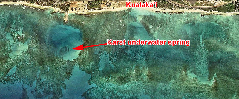
These springs are also likely why this area was a popular ancient fishing and limu spot and why the Kualaka’i fishing village was there and also why the 1825 Malden mapped native Hawaiian trail went there. Fresh underwater springs are major attractants for sea life ecosystems and help limu spawn. Oral histories tell of once bountiful quantities of easily harvested fisheries, from shellfish to pelagic.
The Enduring Song of Uncle Henry Chang Wo Jr.
https://www.civilbeat.org/2015/10/the-enduring-song-of-uncle-henry-chang-wo-jr/
Uncle Henry used to say: “We watch that first raindrop that hits the island. We follow the raindrop all the way to the ocean, we don’t let that raindrop get dirty. Because when that mountain water and that ocean water meet, when they come together that’s when the ocean hānau, that’s when the ocean gives birth. Our fishes depend on that, the estuary, they all need that water from the mountain. If it was only the ocean itself, too salty, she make (dies) and that is what is happening now.”

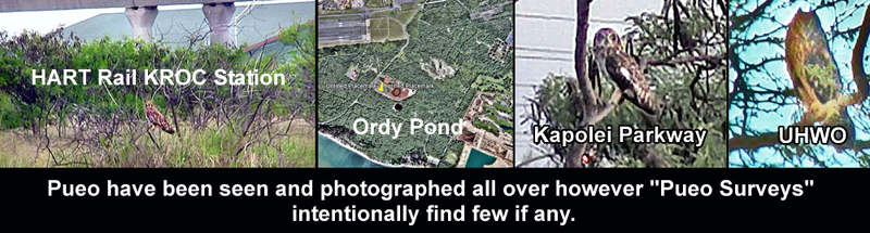
Where Pueo are still seen and the streets named Pueonani (Pueo splendor)
Honouliuli Ewa's Makakilo Kalo'i Gulch - A Rare In Depth Survey Of This Important Cultural Property
http://honouliuli.blogspot.com/2015/06/honouliuli-ewa-makakilo-kaloi-gulch.html
Finally he [Harry von Holt] got them (local Hawaiians) to explain that the spring, called “Waihuna” (Hidden Spring) had been one of the principal sources of water for all the Ewa Plain kalo lo’i (taro patches,) which was quite heavily populated before the smallpox epidemic of 1840 (which killed off much of the population)… A powerful Kahuna living at the spring had hidden it before he died of the smallpox, and had put a curse on the one who disturbed the stone, that he or she would surely die before a year was out. (Von Holt 1985:138-140)
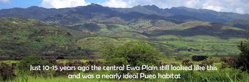
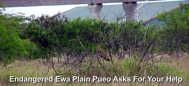
The disappearing Ewa Plain PUEO
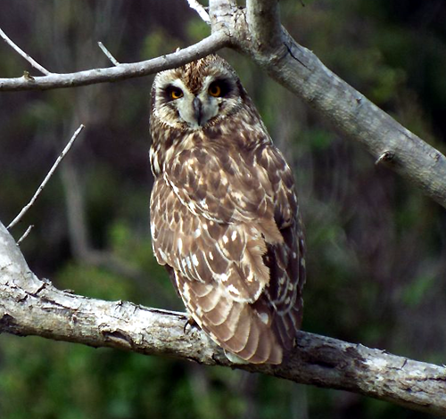

Pueo, Hawaiian short‐eared owl - Asio flammeus sandwichensis (Photos by Forest & Kim Starr)
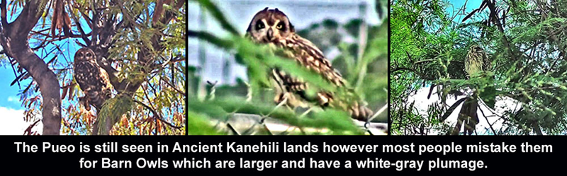
The Pueo (Asio flammeus sandwichensis) is a subspecies of the short-eared owl and is endemic to Hawaii. The Pueo is one of the more famous of the various physical forms assumed by ʻaumākua (ancestor spirits) in Hawaiian culture. In former MCAS Ewa, known in ancient times as Kanehili, the Leina a ka uhane is located where spirits roamed seeking to reach the Polynesian homeland of Kahiki. Connecting with a Pueo aumākua could help them make the journey.

Native Pueo are especially vulnerable to dogs, cats, mongoose because they are ground nesters
Little is known about the breeding biology of Pueo, but nests have been found throughout the year. Males perform aerial displays known as a sky dancing display to prospective females. Nests are constructed by females and are simple scrapes in the ground lined with grasses and feather down. Females also perform all incubating and brooding. Males feed females and defend nests. Chicks do not hatch at the same time and are fed by a female with food delivered by male. Young may fledge from nest on foot before they are able to fly and depend on their parents for approximately two months.
At one time very numerous on Oahu, Pueo is listed by the state of Hawaii as an endangered species on the island of Oʻahu. They have been seen many times throughout the former MCAS Ewa airfield, horse stables and Ewa area golf courses especially in the early morning hours. People often mistake the larger light colored Barn owl (Tyto alba) for Pueo. Unlike the early morning foraging Pueo, barn owls hunt at night and have a distinctive “screech” when locating prey.
The Pueo taxon was first named by Andrew Bloxam (as the species Strix sandwichensis) while on the Ewa Plain in 1825 as the naturalist on board HMS Blonde. It was also during this voyage that Lt. Charles Malden, Royal Navy surveyed and created the important 1825 cultural history map of Hawaiian trails from Honouliuli to Kualaka’i and One’ula. These maps helped later archeologists like the Tuggles (Navy BRAC 1995-97 surveys) establish a cultural landscape of native habitation sites throughout ancient Kanehili (NASBP and MCAS Ewa airfields.)
Pueo or Barn owl: here’s the difference
https://mauiinvasive.org/2015/02/05/pueo-or-barn-owl-heres-the-difference/
https://en.wikipedia.org/wiki/Pueo
https://dlnr.hawaii.gov/wildlife/birds/pueo/
https://www.facebook.com/SavePueoOwl/
Honouliuli Ewa Plain Akoko - An Endangered Native Hawaiian Plant Species
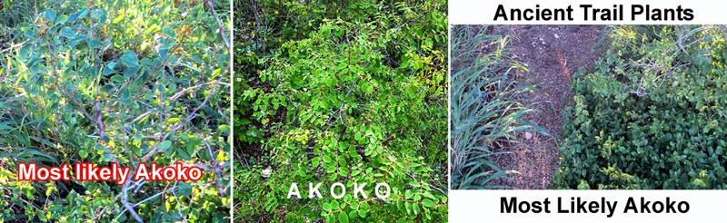
Very rare Akoko identified on ancient Kanehili trail in an unprotected area
The population of Chamaesyce skottsbergii var. kalaeloana, otherwise known as the Ewa Plains Akoko, dwindled from about 5,000 plants in 1979 to just over 630 last year, according to the US FWS.
"If something isn't done to conserve this plant, then it's going to go extinct," said Aaron Nadig, a Fish and Wildlife biologist. Fish and Wildlife has been in contact from the beginning with HCDA and the solar companies that wanted to operate on the land.
"We're at a point where we need to protect a large chunk of this land for the species, because it only exists there," Nadig said. "We were very upfront from the beginning — if they can't do that, then maybe they shouldn't look to do it, and look elsewhere." (HCDA refuses to support any native plant preservation in Kalaeloa ancient Kanehili.)
Ewa Plains `akoko (Euphorbia skottsbergii var. skottsbergii)
Honouliuli Ewa Plain Akoko - Extremely Endangered Native Hawaiian Plant Species found
Along ancient 1825 Malden mapped native Hawaiian trail
http://honouliuli.blogspot.com/2014/12/honouliuli-ewa-plain-akoko-endangered.html
https://sites.google.com/a/nativehawaiiangarden.org/www/flowering-plants/akoko-ewa-plains
Euphorbia skottsbergii var. skottsbergii is a perennial, erect to prostrate shrub 0.5 foot to 3.3 feet tall, occasionally reaching 6.6 feet, with brittle, slender, jointed branches that are minutely hairy, especially when young. The opposite, two-ranked, oval leaves are often with toothed margins, and have a hairless upper surface. Each cyathium (flower cluster resembling a single flower) is situated singly in a leaf axil and consists of a female flower made up of one pistil surrounded by several male flowers, each with a single stamen.
Rare native plant stalls land plans for Kalaeloa
The native Akoko plant can be found at the former northern trap and skeet range at the old Barbers Point Naval Air Station. According to the U.S. Fish and Wildlife Service, the Akoko have dwindled from about 5,000 plants in 1979 to just over 630 last year (That was 2013, likely less now.)
Ewa Puuloa sharks also had their own trails
The classic “Pearly Shells” song may not be what you think it is about!
Pupu O Ewa is about the story of Ewa’s beloved shark goddess protector Ka‘ahupahau and her shark trails
Many locals and tourists learn to play on a ukulele the classic “Pearly Shells” song, and it is one of the most famous songs associated with Hawaii worldwide. The original words however are different. Pupu A O Ewa, is a story of Ka‘ahupahau, the shark goddess and her grandmother.
https://www.huapala.org/Pul/Pupu_A_O_Ewa.html
https://www.hawaiimusicmuseum.org/news/archive/2003/shells.html
Shells of ʻEwa throngs of people
Coming to learn
The news of the land
A land famous
From the ancient times
All of Puʻuloa, the path trod upon by
Kaʻahupāhauʻ
All of Pu`uloa, the path trod upon by
Kaʻahupāhau
Source: Nā Mele `O Hawaiʻi Nei by Elbert & Mahoe, the news of the land was the discovery of pearl oysters in Puʻuloa, the Hawaiian name for Pearl Harbor, protected by Kaʻahupāhau, the shark goddess. And YES, Ewa has a big statue of Ka‘ahupahau, which politicians at the time wanted it hidden away.
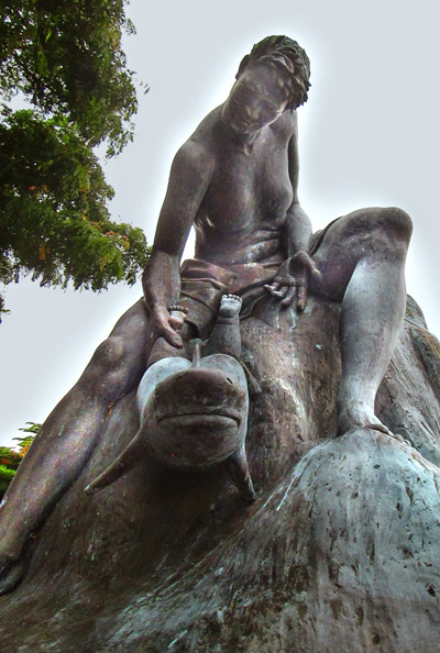
Many people today in Ewa don’t know where this famous statue is located!
THE SWIMMING TRAILS OF PU‘ULOA ARE THE TRAILS TRAVELED BY KA‘AHUPĀHAU
In Ewa, sharks were regarded as aumakua (guardians and protectors) such as shark goddess Ka‘ahupahau who had known underwater trails in the bays of Pu‘uloa (now known as Pearl Harbor), that led to her large coral cave resting place.
In addition to the traditions of Ka‘ahupāhau, two other accounts center around the nature of sharks in the ‘Ewa District, and battles that were fought to kill offending sharks. In the early 1820s, members of the Protestant mission station traveled to the ‘Ewa District, and learned something about the shark gods of Pu‘uloa.
Hiram Bingham accompanied King Kamehameha II (Liholiho), the royal family, and attendants to ‘Ewa in 1823, where they stayed near the shore of Pu‘uloa. During the visit, the king and party, along with Bingham, visited the dwelling place of a noted shark god. The name of the god was not recorded in Bingham’s journal, though one must infer that it was either the goddess Ka‘ahupāhau or her brother, Kahi‘ukā. Bingham wrote:
I one day accompanied the King [Liholiho] and others by boat to see the reputed habitation of a Hawaiian deity, on the bank of the lagoon of Ewa. It was a cavern or fissure in a rock, chiefly under water, where, as some then affirmed, a god, once in human form, taking the form of a shark, had his subterraqueous abode. Sharks were regarded by the Hawaiians as gods capable of being influenced by prayers and sacrifices, either to kill those who hate and despise them or to spare those who respect and worship them. It had been held that, when a mother gave her offspring to a shark, the spirit of the child dwelt in it, and the shark becoming an akua (god,) would afterwards recognize and befriend the mother on meeting her, though ready to devour others. [4:177]
Later, in January 1825, Elisha Loomis also traveled to ‘Ewa and stayed along the Pu‘uloa shore [31]. During his visit, Loomis learned the name of the shark goddess who protected the waters of the Pearl Harbor region, and also reported hearing about a war between the good sharks and those who sought to eat human flesh. It will be noted that due to his limited Hawaiian-language skills, Loomis apparently transposed she for he in his journal.
After supper I conversed with them a long time on the subject of religion … during the conversation one of them mentioned that in former times there dwelt at Puuloa a famous shark named Ahupahau. He had a house in the hole of a rock. He was one their gods. On one occasion a strong shark 3 or 4 fathoms long came into the channel to make war upon the sharks and upon the natives that dwelt there. Ahupahau immediately communicated to the natives information advising them to get a net out and secure him. They took the hint and spread their nets, and in a little time the stranger was captured.
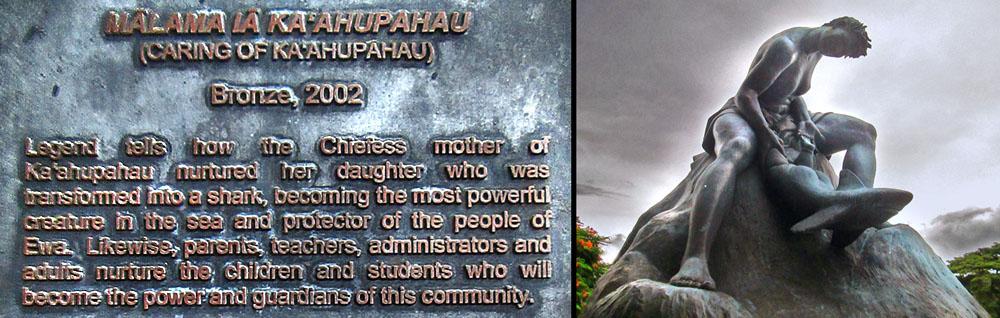
In 1870, native historian S. M. Kamakau wrote about several practices and beliefs pertaining to manō, (sharks,) in ancient life. One practice of note in the Ewa Pu‘uloa region was the practice of transforming deceased family members into manō as ‘aumakua. These family ‘aumakua would help relatives when in danger on the sea—if a canoe capsized or a man-eating shark was threatening an attack. Hawaiians also worked with and tamed sharks so that one could ride them like a horse, steering them to where one wished to go.
Kupuna Mary Kawena Pukui shared that there were two basic classes of sharks—manō kānaka: sharks with human affiliations; and manō i‘a: wild sharks of the sea, man eaters. The manō kānaka were revered and cared for, while the manō i‘a were at times hunted and killed following ceremonial observances. The practice of chiefs hunting sharks using the flesh of defeated enemies or sacrificial victims as kūpalu manō (shark fishing chum), and of commoners using rotted fish as kūpalu manō are further described in several historical narratives.
Ke Awalau o Pu‘uloa, “the many bays of Pu‘uloa” (Pearl Harbor), are famed in traditional and historical accounts of manō. The traditions center around the several deified sharks, foremost of whom is the goddess Ka‘ahupāhau, then followed several others, including but not limited to Kahi‘ukā , Kūhaimoana, Komoawa, Ka‘ehuikimanōopu‘uloa, Keli‘ikau-o-Ka‘ū (Kealiikauaoka‘ū), and Mikololou. With the exception of Mikololou, all these shark gods were friendly to people, and dedicated to keeping manō i‘a, wild sharks of the sea, out of the Pu‘uloa-‘Ewa waters and protecting people.
S. M. Kamakau, January 6, 1870; Pukui, translator, 1976.
2M. K. Pukui, personal communication to Kepā Maly, 1976.
3S. M. Kamakau; Pukui, translator, 1968:73.
4W. H. Uaua, “He Moolelo Kaao no Kaehuikimanoopuuloa,” Ke Au Okoa, Dec. 1, 1870 to Jan. 5, 1871.
5“He Moolelo Kaao Hawaii no Keliikau o Kau,” Home Rula Repubalika, January 6, 1902, p. 7–8.
6J. S. Emerson, 1892:10–11. 7Manu 1895.
8For additional background on the sharks of Pu‘uloa, see Pukui and Curtis, 1961 [27].
Why did FTA, HART and SHPD-DLNR designate the Leina a ka uhane in ancient Kanehili as a National Register TCP-Historic District and is now doing everything possible to suppress this nomination?


The FTA and HART were required to identify important native Hawaiian TCP’s in Ewa West Oahu that might be affected by the HART rail route. FTA contracted with Kumu Pono LLC to identify the important native Hawaiian cultural landscapes and later the report produced was suppressed by developers.


The Oahu BWS held meetings in 2013 about Ewa Watershed Management and recognized native Hawaiian Rights and customary practices. Inside a karst cave later destroyed by developer.
Habitation structures, archeological evidence of native plants all point to a once thriving native Hawaiian culture along the ancient trails
Native Plants still found along Coral Sea Rd in ancient Kanehili – MCAS Ewa all indicate the ancient Hawaiian trail ways supported a large native population.
McAllister’s Archaeology of Oahu, 1904, provides readers with an observation of how the coral plains around the project area may have been used in earlier times:
Site 146. Ewa coral plains, throughout which are remains of many sites. The great extent of old stone walls, particularly near Puuloa Salt Works, belongs to the ranching period of about 75 years ago. It is probable that the holes and pits in the coral were formerly used by the Hawaiians. Frequently the soil on the floor of the larger pits was used for cultivation, and even today one comes upon bananas and Hawaiian sugar cane still growing in them.
Rare native plants still found along ancient Kanehili trails
There would be absolutely no reason for these native plants to be there other than they were brought in and planted within the past century or two. Fortunately the main trails were mapped in 1825 by British royal navy cartographer Malden. And then Navy BRAC contracted archeologists were able to use the map to create the trail routes through ancient Kanehili.
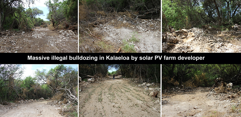
While ORDY POND was being nuked, another Navy insider group jumping on the solar PV farm construction rush illegally destroyed Hawaiian sites and parts of the ancient Kualakai’i trailway

HCDA ``mismanagement” in 2012 allowed the ancient Kualaka’i trail in parcel 13073-E to be destroyed by a PV site developer with a D-9 bulldozer. This parcel was part of the BRAC City Parks land transfer, however an insider deal got it transferred to HCDA for this PV site scheme.
Navy KREP: Broken Agreement Caused Karst Collapse And Subsurface Damage
https://kanehili.blogspot.com/2015/09/navy-broken-agreement.html
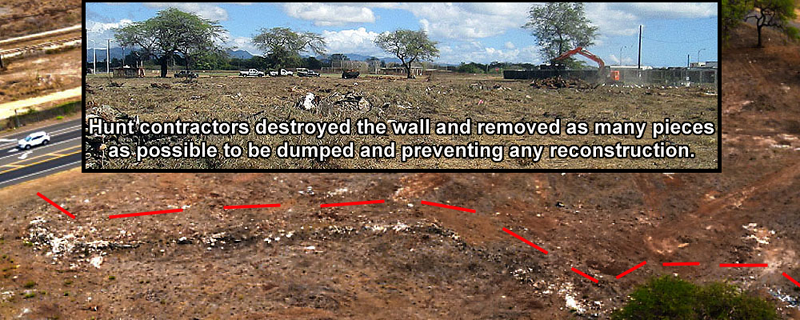
Ewa Coral Limestone Wall Destroyed by Hunt Corp of Texas


Hunt Corp of Texas wanted the parcel as part of a massive asphalt car lot with Navy NavFac supporting that no EIS was required despite huge environmental, cultural and historic concerns
Without any announcement Hunt Corp of Texas brought in their destruction contractors around the end of January 2019 and obliterated a well known 100 year old Ewa historic wall on a small parcel of land adjacent to Roosevelt Avenue. No one in the local community or Hawaii SHPD was notified or consulted. It appears that Hunt Corp has a secret agreement with HCDA to keep Hawaii SHPD out of Kalaeloa as Hunt Corp regularly knocks down historic structures and even bulldozes State DOT property without any prior notice or consultation. Navy NavFac as the responsible federal land owner has been approving all of this for many years in HCDA Kalaeloa.
Navy NavFac’s well known arrogance and corruption is well documented in the infamous Fat Leonard scandal and more recently in the Red Hill public health crisis. Hunt Corp of Texas is Pearl Harbor Navy’s favorite client even though Hunt has long running lawsuits against them to weasel more land and money out of the federal government as they commit illegal violations year after year. Hawaii’s congressional delegation also has close business ties to Hunt Corp.
Navy Hawaii has a long string of arrogance and corruption against Hawaiian culture and people
https://en.wikipedia.org/wiki/Fat_Leonard_scandal
https://en.wikipedia.org/wiki/Red_Hill_water_crisis
https://www.nps.gov/Archeology/tools/laws/ARPA.htm
This wall and parcel is particularly important historically and culturally. It was one of the last remaining visible landmarks of the Ewa Plantation and Sisal Plantation era. It was well recognized by WW-II Navy and Marine Corps contractors and SeaBees and left completely untouched all the way up until 2019 when this damage was intentionally done to the old surviving Ewa landmark wall. This wall appears in many old Ewa maps, 1920’s Army Air Corps photos, and in the 1997-99 Navy BRAC report done by the Tuggles. The Tuggle’s map shows the most likely route of the 1825 Malden (royal navy) Hawaiian trails that went from Honouliuli to the Ewa Coast –the Kualaka’i and One’ula trails.
Close examination of the wall structure in photos taken before it was decimated shows a building technique directly associated with ancient Polynesian settlers who came from Raiatea
In French Polynesia. The wall was technically dated as approximately 100 years old however it was very likely much older. It is very likely that local plantation or ranch laborers used the vertical limestone coral flags from the existing Kualaka’i trail and piled them along an already existing Hawaiian heiau or ahu which eventually became a “wall.” The construction style clearly indicates an ancient technique that is also seen in the last remaining sections of the Kualaka’i trail – many upright vertical coral limestone “flags.” In fact there are numerous other examples of this construction technique along the Tuggle’s projected trail routes in Kalaeloa – ancient Kanehili. The Tuggles were extremely good at observing all of these details and connecting the ancient trail way “dots.”
The wall parcel was almost directly across Roosevelt Avenue where a large deep cave existed by the 1890’s OR&L narrow gauge railway tracks. The cave was later destroyed by the DHHL Ka Makana shopping mall. The ancient trail ran close to the deep cave which may have had special cultural significance and then through the small parcel. The fact that this parcel was NEVER altered or developed during the entire military of Ewa Mooring Mast to MCAS Ewa history all suggests that they were aware that the parcel had a special meaning for local residents, likely with associated Hawaiian cultural stories, the chants of Pele’s sister Hi‘iaka, the spring of Hoakalei, nearby Pu'u o Kapolei, and the first breadfruit tree planted by Kaha’i, a Tahitian Chief. The rapid deaths of most of the Ewa Plain population wiped out by western diseases caused the loss of these local stories and the importance of this particular parcel area was also lost other than among a few local kahuna who kept their closely guarded secrets until they passed away.

Below this special wall parcel along this same ancient trail route noted by the Tuggles are in fact still existing trails, deep sinkholes with Ti plants, Noni, rare endangered Akoko plants and evidence of cave mining for calcite, a sparkling mineral formed inside ancient water caves.
ABOVE- Pacific Legacy archelogy report for the DHHL Ka Makana shopping mall
Archaeological Assessment for the Honouliuli WWTP, Honouliuli, ‘Ewa, O‘ahu
TMK: [1] 9-1-013:007 Cultural Surveys Hawai‘i Job Code: HONOULIULI 105
McIntosh and Cleghorn 1999:
Treatment Plant Determined little likelihood of encountering surface resources, but subsurface resources in form of sinkholes or burials possible. Soil was only about 1 m deep over the coral substrate.
1943 Map – This particular Hawaiian wall was ALWAYS PROTECTED- even during WW-II
Laws and Statutes pertaining to this site:
https://www.nps.gov/archeology/tools/laws/arpa.htm
This statute (16 U.S.C. 470aa-470mm; Public Law 96-95 and amendments to it) was enacted ...to secure, for the present and future benefit of the American people, the protection of archaeological resources and sites which are on public lands and Indian lands, and to foster increased cooperation and exchange of information between governmental authorities, the professional archaeological community, and private individuals (Sec. 2(4)(b)).
https://www.nps.gov/archeology/pubs/techbr/tch20.htm
https://www.law.cornell.edu/uscode/text/16/470ee
(a) Unauthorized excavation, removal, damage, alteration, or defacement of archaeological resources. No person may excavate, remove, damage, or otherwise alter or deface, or attempt to excavate, remove, damage, or otherwise alter or deface any archaeological resource located on public lands or Indian lands unless such activity is pursuant to a permit issued under section 470cc of this title, a permit referred to in section 470cc (h)(2) of this title, or the exemption contained in section 470cc(g)(1) of this title.
(d) Penalties
Any person who knowingly violates, or counsels, procures, solicits, or employs any other person to violate, any prohibition contained in subsection (a), (b), or (c) of this section shall, upon conviction, be fined not more than $10,000 or imprisoned not more than one year, or both: Provided, however, That if the commercial or archaeological value of the archaeological resources involved and the cost of restoration and repair of such resources exceeds the sum of $500, such person shall be fined not more than $20,000 or imprisoned not more than two years, or both. In the case of a second or subsequent such violation upon conviction such person shall be fined not more than $100,000, or imprisoned not more than five years, or both.
In the Environmental Assessment done for the nearby DHHL Ka Makana Ali`i Cultural Impact Assessment (CIA) by Pacific Legacy states: "interviewee also recalls the existence of at least one ahu (shrine) in the general area, which was dedicated to agriculture. This ahu ‘aina stood up to five feet tall and possibly as wide as it was tall. On these ahu, devotees, including the interviewee, would leave offerings to show appreciation for these natural resources and respect for the divine."
Likely Discovery of New Sinkholes, Caves, Hawaiian burials or Disassociated Iwi Remains
The Ewa Kalaeloa Cultural Context, from a larger International Archeological Research Institute Cultural Resource Inventory of NASBP, MCAS Ewa, by the (Tuggles, Denfeld, Yoklavich, MAI, etc.
1997) states: (Native Hawaiian) Burials- High potential for discovery of additional remains in dunes, habitation and untested sinkholes that may have been covered by base construction. Cultural Deposits - High potential for discovery of cultural deposits in dunes, habitation and untested sinkholes in areas with demolished surface features.
Having spoken with various well regarded archeologists they all agree that the last real cultural history and archeology study of the Kanehili area, which was done in 1999, is way out of date. There is still the great likelihood of many archeological sites which have been overlooked, especially below ground caves and sinkholes, which would likely contain iwi.
DRAFT ENVIRONMENTAL ASSESSMENT November 23, 2008
Archaeological Inventory Survey for the Makakilo Drive Extension Project,
Honouliuli, ‘Ewa, O‘ahu
Please view the following shared folder: Malden Trails Maps and Photos
Honouliuli: Ewa Plain Traditional and Historical Background
Honouliuli Ahupua‘a, as a traditional land unit, had tremendous and varied resources available for exploitation by early Hawaiians. Within Honouliuli Ahupua‘a, not only is there a long coastline fronting the normally calm waters of leeward O‘ahu, but there are also four miles of waterfront along the west side of the West Loch of Pearl Harbor. The “karstic desert” and marginal characterization of the limestone plain, which is the most readily visible terrain, does not do justice to the ahupua‘a as a whole. The richness of this land unit is marked by the following available resources:
1. 12 miles of coastline with continuous shallow fringing reef, which offered rich marine Resources
2. Four miles of frontage on the waters of West Loch that offered extensive fisheries (mullet, awa, shellfish) as well as frontage suitable for development of fishponds (for example, Laulaunui).
3. The lower portion of Honouliuli Valley in the ‘Ewa plain offered rich level alluvial soils with plentiful water for irrigation from the stream as well as abundant springs. This irrigable land would have stretched well up the valley.
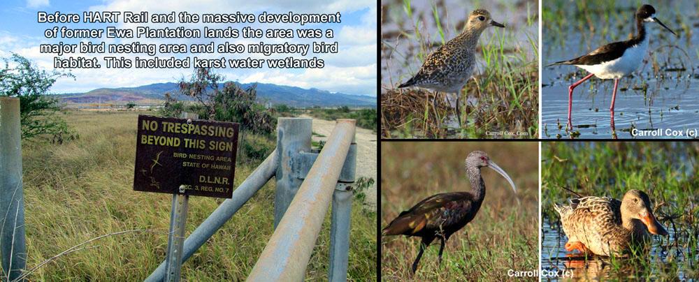
4. A broad limestone plain which, because of innumerable limestone sinkholes, offered a nesting home for a large population of avifauna. This resource may have been one of the early attractions to human settlement.
5. An extensive upland forest zone extending as much as 12 miles inland from the edge of the coastal plain. As Handy and Handy (1972:469) have pointed out, the forest was much more distant from the lowlands here than on the windward coast, but it was much more extensive. Much of the upper reaches of the ahupua‘a would have had species-diverse forest with kukui, ‘ōhia, ‘iliahi (sandalwood), hau, ti, banana, etc.
The political and cultural center of the ahupua‘a is understood to have been the relatively dense settlement and rich lands for irrigated taro cultivation at the ‘ili of Honouliuli located where Honouliuli Stream empties into the north portion of West Loch (east of the present study area). The name of the ahupua‘a, translated as “dark bay” (Pukui et al. 1974:51) may refer to the nature of the waters of West Loch at the mouth of Honouliuli Stream. Early accounts and maps indicate a large settlement at the ‘ili of Honouliuli and it may well be that the political power of this village was so great that it was able to extend its jurisdiction well to the northwest into an area which might have been anticipated to fall under the dominion of the Wai‘anae ruling chiefs.

Horse riders at Barbers Point stables describe many sinkholes throughout the area and the reason why they must stay on proscribed trails when riding.
Honouliuli Ewa Plain Mythological and Traditional Accounts

The traditions of Honouliuli Ahupua‘a have been complied and summarized numerous times, in studies by Sterling and Summers (1978), Hammatt and Folk (1981), Kelly (1991), Charvet-Pond and Davis (1992), Maly et al. (1993), and Tuggle and Tuggle (1997). Some of the themes of these traditions include connections with Kahiki (the traditional homeland of Hawaiians, probably in reference to central Polynesia) and the special character and relationship of the places known as Pu‘uokapolei and Kualaka‘i.
Connections with Kahiki are found in numerous place names, traditional events, and with the beings associated with Honouliuli. There are several versions of Kaha‘i leaving from Kalaeloa for a trip to Kahiki to bring breadfruit back to ‘Ewa (e.g. Kamakau 1991:110). There are several stories that associate places in the region with Kamapua‘a and the Hina family, as well as with Pele’s sisters, all of whom have strong connections with Kahiki (cf. Kamakau 1961:111; Pukui et al. 1974:200).
Pu‘u o Kapolei was one of the most sacred places in Honouliuli (Sterling and Summers 1978:33). Pu‘u o Kapolei’s connections with Kahiki are emphasized when it is noted that the hill was the home of Kamapua‘a’s grandmother, Kamaunuaniho, the Kahiki ancestor to the people of O‘ahu (Fornander 1916-20, V:318; Kahiolo 1978:81, 107). By name, Kapolei is associated with the goddess Kapo, another connection with the Pele and Kamapua‘a stories (Kamakau 1976:14).
McAllister (1933:108) records that a heiau, or temple, was located on Pu‘uokapolei, but was destroyed before his survey of the early 1930s. The heiau may have been associated with the sun (Fornander 1916-20, III:292). The hill was used as a point of solar reference or as a place where such observations were made. Pu‘u o Kapolei might have been understood as the gate of the setting sun. It is notable that the rising sun at the eastern gate of Kumukahi in Puna is associated with the Hawaiian goddess Kapo (Emerson 1978:41).
There is little specific information for Pu‘uokapolei, but the place name itself (“hill of beloved Kapo”) is hard to ignore. It is mentioned in some cosmologies that Kū was the god of the rising sun, and Hina should be associated with the setting sun (Hina is the mother of Kamapua‘a). Fornander (1916-20, III; 292) states, Pu‘u o Kapolei may have been a jumping off place (“Leina” also connected with the setting sun) and associated with the dead who roamed the adjacent Plain of Kaupe‘a.
Pu‘u o Kapolei was also the primary landmark for travelers between Pearl Harbor and the west O‘ahu coast, with a main trail running just inland of it (‘Ī‘ī 1959:27, 29). Pu‘u o Kapolei was probably the most common name used as a reference for the area of the ‘Ewa Plain in traditional Hawai‘i (Nakuina 1992:54; Fornander 1916-20, II: 318; E.M. Nakuina 1904, in Sterling and Summers 1978:34).
The Pele Family at Honouliuli
Kapolei (literally “beloved Kapo”), specifically the 166-foot-high cone of that name, is understood to have been named in reference to one of the volcano goddess Pele’s sisters, Kapo (Pukui et al. 1974:89). Pōhākea Pass is understood as one of the resting places of another of Pele’s sisters, Hi‘iaka, as she was returning from Kaua‘i with Pele’s lover Lohiau (Fornander 1919 Vol. V: 188 note 6). A considerable number of mele (songs) and pule (prayers) are ascribed to Hi‘iaka as she stood at the summit of Pōhākea (Aluna au a Pōhākea, Kū au, nānā ia Puna, in Emerson 1915:162-168). A spring located at Kualaka‘i near Barbers Point was named Hoaka-lei (lei reflection) because Hi‘iaka picked lehua flowers here to make a lei and saw her reflection in the water.
Pre-Contact and Early History
Various Hawaiian legends and early historical accounts indicate that the ahupua‘a of Honouliuli was once widely inhabited by pre-Contact Hawaiian populations, including the Hawaiian ali‘i. This substantial population is attributable for the most part to the plentiful marine and estuarine resources available at the coast, along which several sites interpreted as permanent habitations were located. Other attractive subsistence-related features of the ahupua‘a included irrigated lowlands suitable for wetland taro cultivation (Hammatt and Shideler 1990), as well as the lower forest area of the mountain slopes for the procurement of forest goods.
Exploitation of the forest resources along the slopes of the Wai‘anae Range - as suggested by E. S. and E.G. Handy - probably acted as a viable subsistence alternative during times of famine:
...The length or depth of the valleys and the gradual slope of the ridges made the inhabited lowlands much more distant from the ‘wao, or upland jungle, than was the case on the windward coast. Yet the ‘wao here was more extensive, giving greater opportunity to forage for wild foods during famine time. (Handy and Handy 1972:469-470) These upper valley slopes may have also been a significant resource for opportunistic quarrying of basalt for the manufacturing of stone tools. This is evidenced in part by the existence of a probable quarrying site (50-80-12-4322) in Makaīwa Gulch at 152 m (500 ft.) AMSL, west of the current study area (Hammatt et al. 1991).
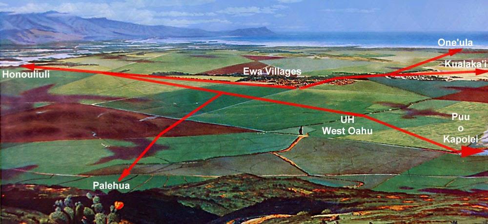
John Papa ‘Ī‘ī describes a network of Leeward O‘ahu trails (Figure 11) which in later historic times encircled and crossed the Wai‘anae Range, allowing passage from West Loch to the Honouliuli lowlands, past Pu‘u o Kapolei and Waimānalo Gulch to the Wai‘anae coast and onward circumscribing the shoreline of O‘ahu (‘Ī‘ī 1959:96-98).
Other early historical accounts of the general region typically refer to the more populated areas of the ‘Ewa district, where missions and schools were established, and subsistence resources were perceived to be greater. However, the presence of archaeological sites along the coral plains and coast of southwest Honouliuli Ahupua‘a, indicate that prehistoric and early historic populations also adapted to fewer inviting areas, despite the environmental hardships.
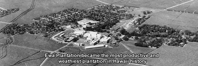
The Oahu Sugar Co. was incorporated in 1897 and included lands in the foothills above the ‘Ewa plain and Pearl Harbor. Prior to commercial sugar cultivation, the lands occupied by the Oahu Sugar Co. were described as being “of near desert proportion until water was supplied from drilled artesian wells and the Waiāhole Water project” (Conde and Best 1973:313). The Oahu Sugar Co. took control over the Ewa Plantation lands in 1970 and continued operations into the 1990s.
Dillingham’s mauka lands in western Honouliuli that were unsuitable for commercial sugar production remained pasture for grazing livestock. From 1890 to 1892 the Ranch Department of the O.R. & L. Co. desperately sought water for their herds of cattle by tapping plantation flumes and searching for alternative sources of water. Ida von Holt leaves this account of her husband Harry’s (Superintendent of the O.R. & L Ranch Dept.) search for water in the foothills of the Wai‘anae Range:
One of those places is on the old trail to Palehua, and had evidently been a place of which the Hawaiians had known, for its name is Kaloi (the taro patch), and even in dry weather water would be standing in the holes made by the cattle, as they tried to get a drop or two. (Von Holt 1985:136)
It is believed that the spring depicted in this account may have been located during an inventory survey of the adjacent Pālehua East B project area (Tulchin and Hammatt 2005). The spring was located along the upper slopes of the southern face of Kalo‘i Gulch. A second account is given of the discovery of spring water in an area over the ridge on the north side of Kalo‘i Gulch:
Shouting to the men to come over with their picks and shovels, he [Harry von Holt] soon got them busy clearing away lots of small stones and earth. Almost at once they could see that there was evidence of a paved well, and at about three feet down they came upon a huge flat rock, as large around as two men could span with their arms. Digging the rock loose and lifting it to one side, what was their astonishment to find a clear bubbling spring! (Von Holt 1985:138).
Following the discovery, two old Hawaiians began to ask Von Holt about the spring: Finally, he [Harry von Holt] got them to explain that the spring, called “Waihuna” (Hidden Spring) had been one of the principal sources of water for all that country, which was quite heavily populated before the smallpox epidemic of 1840… A powerful Kahuna living at the spring had hidden it before he died of the smallpox and had put a curse on the one who disturbed the stone, that he or she would surely die before a year was out. (Von Holt 1985:138-140)
Honouliuli Taro Lands
Centered around the west side of Pearl Harbor at Honouliuli Stream and its broad outlet into the West Loch are the rich irrigated lands of the ‘ili of Honouliuli, which give the ahupua‘a its name. The major archaeological reference to this area is Dicks, Haun and Rosendahl (1987) who documented remnants of a once widespread wetland system (lo‘i and fishponds), as well as dryland cultivation of the slopes.
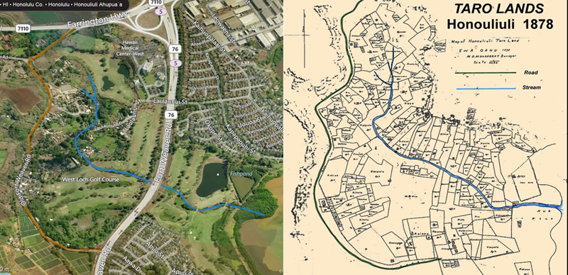
Carol Silva has conducted “Historic Research Relative to the Land of Honouliuli” (Dicks et al. 1987) and the reader is referred to this work for an overview of the history of Honouliuli. The area bordering West Loch was clearly a major focus of population within the Hawaiian Islands, and this was a logical response to the abundance of fish and shellfish resources in close proximity to a wide expanse of well-irrigated bottomland suitable for wetland taro cultivation. The earliest detailed map (Malden 1825) shows all the roads of southwest O‘ahu coalescing and descending the pali as they funnel into the locality (i.e., Honouliuli Village) which gave the ahupua‘a of Honouliuli its name. Dicks et al. (1987:78-79) conclude, on the basis of 19 carbon isotope dates and 3 volcanic glass dates, that “agricultural use of the area spans over 1,000 years.” Undoubtedly, Honouliuli was a locus of habitation for many thousands of Hawaiians.
Oahu's Best Farmland Destroyed And Covered In Asphalt And Concrete
http://honouliuli.blogspot.com/2015/03/hoopili-insanity-farmland-Destroyed.html
Ewa Farm Land Conversion To Commercial Development Unconstitutional
http://honouliuli.blogspot.com/2015/04/Hawaii-Important-Agricultral-Lands.html
Ewa Plain Major 1000 Year Old Native Hawaiian Burial Grounds
http://honouliuli.blogspot.com/2015/01/HART-rail-drills-into-burials.html

Native Hawaiian Traditional Cultural Places Destroyed By Unindicted Co-Conspirators
Pu‘u Ku‘ua: Inland Settlement
Documentation of inland settlement in Honouliuli Ahupua‘a is more problematic in that there are relatively few documented archaeological sources. However, it is probable that the area around Pu‘u Ku‘ua, on the east side of the Wai‘anae Ridge, seven miles inland of the coast, was a Hawaiian place of some importance.
McAllister recorded three sites in this area, two heiau (134 - Pu‘u Kuina and 137 -Pu‘u Ku‘ua, both destroyed) and a series of enclosures in Kukuilua which he calls “kuleana sites” (McAllister 1933). On the opposite side of the Wai‘anae range, along the trail to Pōhākea Pass, Cordy (2002) states “Kākuihihewa was said to have built (or rebuilt) Nīoi‘ula, a po‘okanaka heiau (1,300 sq. m.) in Hālona in upper Lualualei, along the trail to Pōhākea Pass leading into ‘Ewa, ca. A.D. 1640-1660” (Cordy 2002:36).
It was unclear whether the water observed in the marshy area and flowing into the gulch originated from within the land (i.e., a spring) or through a storm drain outlet from the residential area to the west. However, the description of the location of the Kalo‘i Spring given by Von Holt (see Section 3 Background Research) as being near to the trail to Pālehua, which passes through the current project area, suggests this may be a natural spring.
Cultural Impact Assessment for the
Approximately 23-acre Makakilo Drive Extension Project,
Honouliuli Ahupua‘a, ‘Ewa District, O‘ahu Island
2009-03-08-OA-FEA-Makakilo-Drive-Extension.pdf (hawaii.gov)

Background research yields the following relevant information:
The area is located in the Kalo’i Gulch floodplain, which includes the Kalo‘i Stream channel. Kalo‘i, which translates as “the taro patch,” was a well-known place of Native Hawaiian activity from before the historic era. The presence of several small fresh-water springs in the general gulch system, as described in historic accounts, suggests Hawaiians used at least portions of the project area as agricultural sites.
The project area also contains remnants of one or more old Hawaiian trails
Several participants are very concerned about one or more trails crossing through the subject project area; at least one of the trails is perceived to be an old Hawaiian trail dating from early historic or perhaps even pre-Contact times. Mr. Shad Kane, in particular, stressed that this trail—part of which is depicted in Figure 23— should not be sacrificed or physically compromised to make way for the proposed project.

Several participants talked about a wide variety of “ghost stories” and unexplained phenomena either experienced personally or related by others in old stories dealing with the general vicinity of the project area and extending to much of the entire ahupua‘a of Honouliuli.
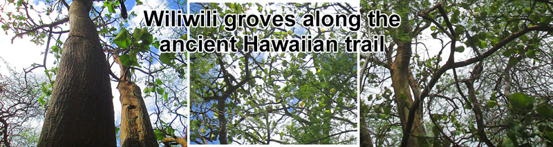
Some participants stressed the importance of not losing any additional Hawaiian features of the landscape, such as trails, to development in and around the project area, which has experienced substantial losses in historic and more recent times. One participant talked about the cultural significance of wiliwili trees (Erythrina sandwicensis), which are closely associated with “ao kuewa,” a kind of Hawaiian purgatory.
The old Hawaiian trail depicted in Figure 23 of this report, and described by several participants in this CIA, should be preserved in its entirety and protected from potential harm during project construction. Preservation and protection of this trail may require a formal preservation plan with additional fieldwork directed towards obtaining accurate GPS data to adequately mark and flag the feature during construction.
It is important to highlight the presence of mature healthy Wiliwili and ‘Iliahi (sandalwood) trees, both of which are rarely seen in developed and populated areas in O‘ahu. Both of these trees are culturally significant to Kānaka Maoli (Native Hawaiians), a topic that is considered in more depth further in the report.
Ancient and Historic Trails
There are several different references to trails in relation to the current project area. John Papa ‘Ī‘ī’s (1959) well-known descriptions of a network of leeward O‘ahu trails (see Figure 12) has been discussed above (see Section 3.3 Pre-Contact and Early History). ‘Ī‘ī described in general terms several major trail systems that in later historic times circled and crossed the entire island.
One of these major trails passed from West Loch (western side of Pu‘uloa, or Pearl Harbor) through the Honouliuli lowlands—relatively close to the subject project area and in the general vicinity of the H-1 highway, past Pu‘u Kapolei and onto the Wai‘anae coast, eventually circumscribing the entire shoreline of O‘ahu (‘Ī‘ī 1959:96-98).
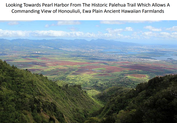
Another trail, known as the Pālehua Trail, oriented roughly northwest by southeast and traversing the middle of the project area, appears to date from historic late 19th century times, and perhaps represents an earlier pre-Contact Hawaiian trail.
Historic accounts of a Mr. Harry von Holt (Superintendent of the O.R. & L Ranch Department in the 1890s) describe his efforts to find water in the foothills of the Wai‘anae Range. Part of this search led to the description of the Pālehua Trail, along which were noted several small fresh-water springs that doubtless were known to local Native Hawaiians at that time.
Restore The 1825 Malden Mapped Ancient Hawaiian Trails On The Ewa Plain
http://honouliuli.blogspot.com/2015/01/plan-to-restore-1825-malden-trails.html
Ancient Historic Ewa Plain Trails Being Destroyed By HART Rail Land Developers
http://honouliuli.blogspot.com/2014/12/
Finally, several participants described an ancient Hawaiian trail within the project area (see Figure 24) that runs from the bottom of Kalo‘i Gulch up towards the connection point of Makakilo Drive. The trail runs adjacent to the proposed project route below the Wai‘anae side ridgeline of Kalo‘i Gulch. Part of the trail has been destroyed in previous development projects. The remaining portion is a major concern for community members we interviewed.
Shad Kane, member of ‘Ahahui Siwila Hawai’i O Kapolei Hawaiian Civic Club, was interviewed by CSH at his home in Makakilo on April 24, 2008. As a Hawaiian cultural practitioner, Mr. Kane kindly shared his knowledge about the cultural significance of Kalo‘I Gulch and the area surrounding the Makakilo Drive Extension Project.
SK: The thing in my mind that’s most important is that Hawaiian Trail. Because this is it, this is the end of it. We actually have given it away for past projects for people to have beautiful homes. There’s only one piece of the trail left. It’s right where Makakilo Drive ends. So, hopefully they don’t destroy what’s left. The scary part is that the Makakilo Drive extension will have to cross over the gulch to get to the ridge. This crossing will be right over the trail. You can actually still see the trail. It's the dry season now so you can see the trail easier. This Hawaiian trail is higher up on the ridge. So the trail is very close to their proposed routes for Makakilo Drive. The biggest impact that I see is going to be on the trail.
Douglas ‘McD’ Philpotts
Douglas McDonald Philpotts (McD) is a long-time resident of the ahupua‘a of Honouliuli. His current residence in upper Makakilo has been his family’s home since 1970. He is a cultural practitioner in the art of Hawaiian woodworking. McD was previously interviewed by CSH for the Waimanalo Gulch Landfill Expansion Project in 2007 and again for the Makakilo Drive Expansion Project in June of 2008. Mr. McD Philpotts also expressed his concern for the remains of an ancient Hawaiian trail located in Kalo‘i Gulch that travels upwards to where he lives now. As a child, McD would walk along this trail from Old Farrington Highway to the uplands of Pālehua to get home from school.
This community went out in a flash. So that whole oral tradition of passing it on it was just wiped out right there.
According to Bushnell (1993), at the time of the arrival of the first foreigners in 1778, the Hawaiian population was approximately 300,000. By the year 1820, when the first missionaries landed, the population was estimated at 150,000. Outbreaks of diseases, infections and other illnesses contributed greatly to the depopulation of the Native Hawaiians. By the time of the overthrow (or occupation, according to some) of the Hawaiian Kingdom in 1893, the Native Hawaiian population was reduced by 87 percent to about 40,000. McD shared the following statements about the native Hawaiian population in Honouliuli Ahupua‘a:
At a certain point, there may be 5 to 10 percent of the population left. Honouliuli was the major population center for the surrounding area. If the population had survived the massive outbreaks of diseases, or even if the surrounding communities had survived or were more intact, we would have so much more mo‘olelo to give us all the clues to this. I really feel we got to put together every little drop from the physical evidence to looking at the alignments, looking at chants and things that have been recorded, newspaper clippings that mention this place in relationship to all the places around our state and it gives you an idea of the importance of this place. It makes you want to go farther. This community went out in a flash. So that whole oral tradition of passing it on it just wiped out right there.
Stories Related To The 1825 Malden Trails of Honouliuli Ewa
Researched by Kumu Pono Associates LLC for the HART Rail Project
ARCHIVAL-HISTORICAL DOCUMENTARY RESEARCH, (kumupono.com)
It is the Hawaiian experience that these trails were, and still remain, important features of the cultural landscape. Even in circumstances where physical remains of the ancient trails have been erased by development and modern land use, it is believed that the po‘e kahiko (ancient people) still walk the land—sometimes in huaka‘i p (processions of night marchers) (Luomala 1983; Interview with Thelma Parish, May 2, 1997, Maly and Maly 2011b:818).
1885: Viewing The Ranches, A Visit to the Upland Region of Honouliuli Ranch,
and Travel Across the Mountain Trail at Pohakea
Below, readers are provided a historical perspective of the ‘Ewa District, with the steady change in land use, and vast development of lands under the control of ranches.
August 31, 1885 (pages 2-3) Daily Bulletin, Honouliuli Ranch, Wednesday, Aug. 12th.
This was the second day’s riding over the Honouliuli Ranch, and a more exciting and romantic excursion could hardly have been made. The start was made, as before, from the ranch house, and lay over a part of the wide flat traversed yesterday, and which, as before stated is well covered with the ilima, indigo and other shrubbery much relished by cattle. The shrubbery, I omitted to mention yesterday, is richly supplemented by an undergrowth of manienie grass.
Thursday, Aug 13th
[returning to ‘Ewa via the low land trail] …The trail leads over coral which is evidently upheaval. Up through every crevice and around every boulder, big and little, there are thick growths of pili, makuekue, pualele (milk weed), manienie, Kukaepuaa and other native grasses.
At one place, a cavity in the rocks contains luxuriant growths of breadfruit, bananas, sugar-cane, and numbers of wiliwili trees, with their exceptionally pretty red seeds. The natives say when these seeds are ripe and red, there are plenty sharks off Puuloa. (An increased risk of being bitten by a shark during October through December. Early Hawaiians recognized this, and cautioned against going in the water at that time.)
As pasture land this portion of the land is unsurpassable in richness. It is the part of Honouliuli designated the fatting paddock. Cattle intended for the slaughter house are brought here to have the “gilt edge” finish put on them. About six head are slaughtered every day for the Honolulu market and forwarded by the steamer Kapiolani. The ranch is capable of supplying a much larger daily quota of beeves, but the demand is limited and the ranch is of course stocked considerably short of its capacity. There are at present on it some 5,500 head all told. But if the grasses, and other plants in their present condition, mean anything, they indicate enough and to spare for herds numbering twice five thousand.
Ewa Plantation Abundant water supply
One peculiarity of the Ewa Plantation which receives the unqualified endorsement of the manager is the source of the water supply. The main dependence will be artesian wells, and as the water does not naturally rise to the required height, the cost of pumping must be taken into account, but notwithstanding that it is claimed to be the best, inasmuch as water can be had in sufficient quantities when it is most needed, which is not the case when the supply is from mountain streams; for when those streams are lowest is the particular time of the year when the most water is needed.
Another thing in favor of the Ewa Plantation is the fact that one account of its low altitude and the corresponding warmth of its soils a crop of cane can be matured there in from six weeks to two months less time than in some places where cane is successfully raised on these islands.
Recollections of Life and Events in ‘Ewa (1836 to 1900)
Sereno E. Bishop, son of Reverend A. Bishop moved to Waiawa in 1836. Though not particularly friendly to Hawaiians or their kingdom, he recorded many facets of Hawai‘i’s history, which shed light on some places and events he experienced. In addition to managing the ‘Ewa mission station, manager from the church at Ha‘upu, and lands awarded to the A.B.C.F.M. S.E. Bishops’ father also assisted in conducting surveys during the period of the Mahele. The narratives below, published in The Friend (1901), provide readers with some of Bishops’ recollection of his early life in ‘Ewa and changes over time.
May 1901, The Friend, Old Memories of Hawaii by S. E Bishop
The once pristine waters of Wai Momi (Pearl Harbor) pollution began with cattle ranching
The lochs or lagoons of Pearl River were not then as shoal as now. The subsequent occupation of the uplands by cattle denuded the country of herbage, and caused vast quantities of earth to be washed down by storms into the lagoons, shoaling the water for a long distance seaward. No doubt the area of (ancient Honouliuli village) deep water and anchorage has been greatly diminished. In the thirties, the small pearl oyster was quite abundant, and common on our table. Small pearls were frequently found in them. No doubt the copious inflow of fresh water favored their presence. I think they have become almost entirely extinct, drowned out by the mud. There was also at Pearl River a handsome speckled clam, of delicate flavor, which contained milk white pearls of exquisite luster, and perfectly spherical. I think that clam is still found in the Ewa lochs.
But the greatest change in Ewa is in the almost extinction of the native population. Some 4,000 Asiatic laborers have taken their places, and few Hawaiians are to be seen. The few who remain have abundant means, renting their lands to the industrious Chinese.
The greatest destruction of the Hawaiian population took place in the summer of 1853, by an invasion of small-pox. This broke out in Honolulu. Rev. A. Bishop immediately procured a supply of vaccine matter, which proved to be spurious. He then proceeded to inoculate the people with small-pox, thus saving hundreds of lives, and himself coming down with varioloid (milder form of smallpox ,) having formerly been vaccinated. But more than half the population of Ewa perished in a few weeks. The earliest cases were pathetic. A young woman in Kalauao was visiting Honolulu, and contracted the malady. She hastened home in terror and summoned her friends and kindred from all the villages of Ewa to bid her farewell. They all came and kissed her, then returned to their homes and all died. The young woman herself recovered.
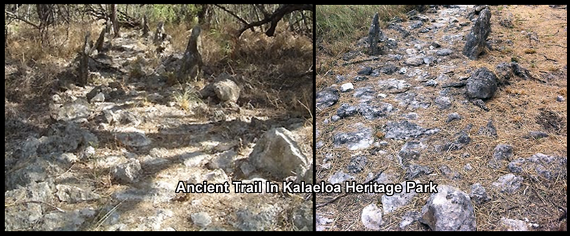
More contemporary cultural practices taking place in the area have included the gathering of ‘uha loa (Waltheria indica) for traditional Hawaiian medicine and ‘alae (red clay) for coloring salt, medicine, dye, and spiritual purification.
Native Hawaii plants found along ancient Kanehili Trails along either side of Coral Sea Rd


Ki - Hawaiian Ti-Plant (Cordyline terminalis)
https://bigislandnow.com/2016/08/04/ti-leaf-canoe-plant-of-ancient-hawaii/
https://www.primitiveways.com/ki.html
The Hawaiian ti plant is known by a few common names including good luck plant and ti leaf. It’s also known as the cordyline terminalis or c. fruticosa and other synonyms (scientific names). Besides its use in kahuna healing practices, the large ti leaves became roof thatching, wrappings for cooking food, plates, cups for eating food, fishing lures on hukilau nets, woven into sandals, ancient and modern hula skirts, headdresses, leis and rain capes.
Introduced by the early Polynesians, ti has a tall stalk with tightly clustered green, oval and blade-shaped leaves. The leaves are generally about 4 inches wide and from 1 to 2 feet long. Ti plants can reach to 12 feet or more in height. There are many ti plants still found along ancient Kanehili trails.
Ki (Ti) was sacred to the Hawaiian god Lono and to goddess of hula, Laka. It was also an emblem of high rank and divine power. The kahili (ceremonial standard), in its early form, was a Ki stalk with its clustered foliage of glossy, green leaves at the top. The leaves were used by the kahuna priests in their ancient religious ceremonial rituals as protection to ward off evil spirits and to call in good spirits.
Boiled Ti roots were brewed into a potent liquor known as 'okolehao. The large, sweet starchy roots were baked and eaten as a dessert. It also had many medicinal uses and as a wrapping for other herbs needing to be steamed or boiled. Ti leaves were wrapped around warm stones to serve as hot packs, used in poultices. A drink from boiled green ti leaves were used to aid nerve and muscle relaxation. Steam from boiled young shoots and leaves made an effective decongestant. The pleasantly fragrant flowers were also used for asthma.
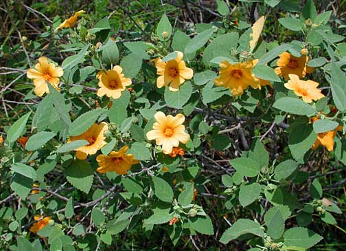

Yellow Ilima - Sida fallax
https://en.wikipedia.org/wiki/Sida_fallax
The ilima was a sacred flower to the goddess of hula, Laka, and the hula ilima lei was worn by dancers as well as placed on altars to Laka. About 1,000 ilima blossoms are needed to make one strand of a lei. The ilima plants are found in profuse amounts in ancient Kanehili.
Sida fallax, known as yellow ilima or golden mallow, is a species of herbaceous flowering plant in the Hibiscus family, Malvaceae, indigenous to the Hawaiian Archipelago and other Pacific Islands. Plants may be erect or prostrate and are found in drier areas in sandy soils, often near the ocean. Ilima is the symbol of Laloimehani and is the flower for the islands of Oahu, Hawaii. Yellow Ilima is found all over very large areas of former MCAS Ewa Field and is attractive for feral honey bees which in karst sinkholes.
Noni - Morinda citrifolia
https://en.wikipedia.org/wiki/Morinda_citrifolia
https://www.ctahr.hawaii.edu/noni/horticulture_production.asp
Morinda citrifolia is a fruit-bearing tree in the coffee family, Rubiaceae. Its native range extends across Southeast Asia and Australasia, and was brought to Oahu by Polynesian sailors.
A variety of beverages, juice drinks, powders cosmetic products oil from seeds, leaf powders have been created and introduced into the modern consumer market.
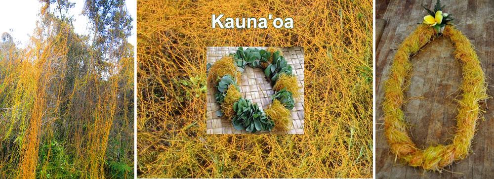
kauna‘oa, Hawaiian dodder Cuscuta sandwichiana
Cuscuta sandwichiana - Wikipedia
https://www.ksbe.edu/article/na-ano-hana-lei-types-of-lei-making#rightrail_photos-4
http://data.bishopmuseum.org/ethnobotanydb/ethnobotany.php?b=d&ID=kaunaoa
This parasitic plant can be found growing on a variety of plants in ancient Kanehili, and also commonly in sandy soil near the Ewa Kualaka’i shoreline (Wagner et al. 1990:583). belonging to the morning-glory family, it a leafless, parasitic vine, growing densely on other plants. It was commonly used as a garland on the head and by ancient hula dancers.
Cuscuta sandwichiana is a twining vine with thin, leafless yellow to yellow-orange stems and very small yellowish flowers which grow in small clusters along the stems. Medicinal: Plants of both kaunaʻoa kahakai and kaunaʻoa pehu were pounded until soft, strained, and juice drunk to thin blood for women who had given birth or who had thick blood.

Maiapilo - Capparis sandwichiana
http://nativeplants.hawaii.edu/plant/view/Capparis_sandwichiana/
https://hawaiiannativeplants.com/ourplants/maiapilo/
This is an exceedingly rare endemic plant in ancient Kanehili that is found along the ancient trails.
Maiapilo has very showy bright white flowers with 120-180 stamens and lemon yellow centers. The flowers open after sunset and bloom into the early morning hours fading to pink by mid-day. The fragrance is described as having a lemony scent.
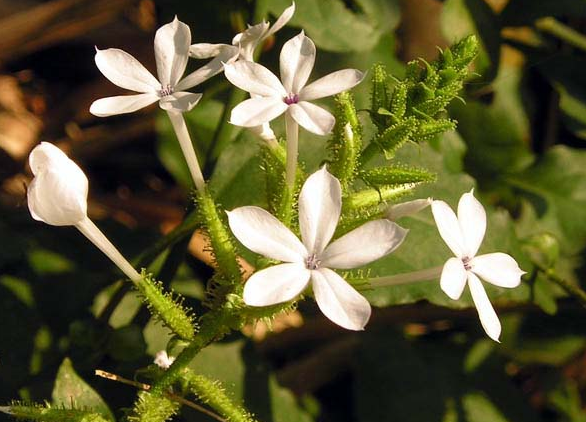

ʻIlieʻe - Plumbago zeylanica - White leadwort
https://en.wikipedia.org/wiki/Plumbago_zeylanica
http://nativeplants.hawaii.edu/plant/view/Plumbago_zeylanica/
ʻIlieʻe has white tubular flowers with green ribs and blue and purple anthers. Flowers grow on racemes.
The sap of ’Ilie’e root was used by Hawaiians to blacken (darky navy blue) tattoos. ʻIlieʻe is a strong ground cover and ideal for stabilizing soil erosion.


Naio Myoporum sandwicense False sandalwood
https://en.wikipedia.org/wiki/Myoporum_sandwicense
https://www.ctahr.hawaii.edu/hawnprop/plants/myo-sand.htm
The finely-textured wood of M. sandwicense is hard and has a specific gravity of 0.55.Native Hawaiians, who called the wood ʻaʻaka, used it to make manu (bow and stern ornamental end pieces) and pale (gunwales) for waʻa (outrigger canoes), pou (house posts),haha ka ʻupena (fishing net spacers), and lamalama (long-burning torches for night fishing). The oily wood was also used as a substitute for ʻiliahi (Santalum spp.) due to the similarity in smell when burned.
The shiny or waxy green leaves vary in shape from long and narrow to elliptic and can be anywhere from 1 1/2 to 8 inches in length. Myoporum sandwicense blooms year round. The 1/4 inch bell-shaped flowers are fragrant. They are arranged close to the stems and range in color from white to pink. (Bornhorst 1996; Koob 1998; NTBG 1996; Rauch 1997; Wagner 1990)
When ʻiliahi or sandalwood was being logged off in great quantities during the Sandalwood Trade, Naio (Myoporum spp.) was trying to be passed off as genuine sandalwood with little success. It did not fool many people and was soon rejected by importers. Naio has thus acquired the pitiful nickname of "bastard sandalwood.”

Big Bucks For Solar PV Farms however HCDA doesn’t want some of the profits to go for any Akoko preservation
In 2011, the HCDA, a state agency, proposed an ambitious solar energy farm for the Navy parcel that used to be a skeet range, as well as on 80 acres of an adjoining southern trap and skeet range. No Akoko has been identified on the southern parcel, officials said. That later became a plan for 5 to 10 megawatts of photovoltaics on the northern site and 5 megawatts on the southern parcel, said HCDA's executive director.
Meanwhile HCDA will pursue a 5-megawatt solar farm on a separate land parcel it already received at Kalaeloa. (Romy Cachola, then on the Honolulu City Council, got the parcel intended for City Parks transferred to HCDA… Then not long after, the parcel was massively and illegally bulldozed by the Navy connected developers, anxious to get on the $$$ PV farm profit bandwagon, destroying Hawaiian sites and part of the Kualaka’i native trail identified in Malden’s 1825 map.)
The Fish and Wildlife Service, meanwhile, disputes Ching's contention that it didn't want the three parcels of land, which include the two former skeet ranges and Ordy Pond, a nearby 10,000-year-old water-filled karst sinkhole. "That wasn't the situation," said Nadig, the Fish and Wildlife biologist. "The situation was that the Fish and Wildlife Service did want it, and they've actively pursued trying to include that as part of their conservation lands out there at Barbers Point."
But Fish and Wildlife didn't have the ability to take the land because of lead contaminants at the old skeet ranges and military dumping in and around Ordy Pond, Nadig maintained. "Without the Navy maintaining liability for those contaminants, then Fish and Wildlife does not have the ability to
acquire those lands," he said.
The Navy "essentially refused to maintain that (responsibility)” and said, “You need to take it as is,'" Nadig said. As for the "unfunded mandate" claim that Ching makes against Fish and Wildlife, Nadig said, "We did not impose anything on HCDA, or we're not telling HCDA they have to do anything."
A 2011 Navy environmental assessment for the disposal of surplus property at the old Barbers Point said the northern trap and skeet range was in active use in 1950 and abandoned sometime before the early 1960s. A lead and arsenic removal project was conducted in 2003 and 2004, with about 52,000 cubic yards of material "stabilized" using "triple super phosphate" and 42,000 cubic yards processed through mechanical screens.
The assessment said soil with Akoko clusters was manually excavated to preserve the plants. The Navy said the actions cleaned the site to U.S. Environmental Protection Agency "unrestricted use" levels.
Nadig said there is still the potential of finding contaminants. "You can still find lead out there," he said.
Ewa Plains Akoko thrived on the coral shelf substrate that underlies the area and which is full of karst sinkholes and underground waterways as a result of erosion."The history of this plant is that it was probably found across the whole Ewa Plain in that coral reef area," said Vickie Caraway, a Fish and Wildlife botanist.
Development, including the Barbers Point Deep Draft Harbor, took its toll on the population, she said.
From 2003 to 2008, the Navy created an Akoko nursery on the northern trap and skeet range lot and that resulted in an increase in the plant population, Caraway said. (However since then the endangered plants have all been left to die. Then, HCDA can put a solar farm on it and collect all the profits.)
Rare native plant stalls land plans for Kalaeloa
Ewa Plain Akoko - An Endangered Native Hawaiian Plant Species
http://honouliuli.blogspot.com/2014/12/honouliuli-ewa-plain-akoko-endangered.html
Rare Endangered Hawaiian Kalaleoa Akoko Plants – Kanehili Cultural Hui video
https://www.youtube.com/watch?v=3XUtiyzqfbY
Polynesian Canoe Food –Hawaiian Trail Food

Canoe Food – Trail Food - What Polynesians brought with them in canoes and planted near their habitation sites along the ancient Kanehili trails because of the abundant fresh water in the karst sinkholes.
Archeological evidence has been found in ancient Kanehili site midden (refuse piles) of sweet potato, breadfruit and gourds. The actual plants have disappeared because the patches needed regular watering with Ipu – Gourds (Ipu hue wai pawehe.) However, archeological analysis of site data in ancient Kanehili reveals that these plants were once there and used on a regular basis. Ti and Noni plants are the only known Kanehili trail food survivors. Ti has deep roots and has many uses including as a wrapper to protect contents and keep it fresher.
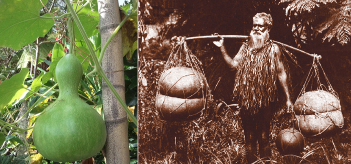
Bottle Gourd (Lagenaria siceraria) Calabash
https://en.wikipedia.org/wiki/Calabash
Shape and Form of the Hawaiian Gourd
I Ke Ēwe ʻĀina o Ke Kupuna: Hawaiian Ancestral Crops in Perspective
https://www.mdpi.com/2071-1050/10/12/4607/htm
In order to water Kanehili trail crops someone would need to be growing gourds someplace nearby.
On the Ewa Plain and in Kanehili the Bottle Gourd (Lagenaria siceraria) was likely the typical plant grown for this purpose. The Bottle Gourd is a large-leaved climbing vine that grows in well-aerated volcanic soils, in sunny areas with moderate rainfall. It has a large fruit that is typically flask-shaped.
Calabash is also known as bottle gourd, white-flowered gourd, long melon, birdhouse gourd, and opo squash, is a vine grown for its fruit. It can be either harvested young to be consumed as a vegetable, or harvested mature to be dried and used as a utensil, container, or a musical instrument. Gourds were used to make a wide range of specialized containers, musical percussion instruments, rattles, drums, whistles, and toys.
Sweet potato - 'uala
https://en.wikipedia.org/wiki/Sweet_potato#Nutrient_content
https://thishawaiilife.com/hawaiian-sweet-potato/
https://ntbg.org/news/uala-hawaiian-sweet-potato/
“He ‘uala ka ‘ai ho’ola koke i ka wi” – Sweet potato is the food that quickly restores health after famine
The 'uala is no longer found along the ancient Kanehili trails however it would have been in ancient times. It is of course still very popular today as a healthy food snack.
The first Hawaiian voyagers arrived in the Hawaiian Islands with approximately two dozen plants that were important enough to earn space on the crowded outrigger canoes used to cross the ocean. These ‘canoe plants,’ as they are known, were vital for providing food, fiber, medicine, and more. Many of these plants had multiple uses. Three were essential staple food crops — kalo (taro), ulu (breadfruit), and uala (Hawaiian sweet potato).
The first Hawaiian voyagers arrived in the Hawaiian Islands with approximately two dozen plants that were important enough to earn space on the crowded outrigger canoes used to cross the ocean. These ‘canoe plants,’ as they are known, were vital for providing food, fiber, medicine, and more. Many of these plants had multiple uses. Three were essential staple food crops — kalo (taro), ulu (breadfruit), and uala (Hawaiian sweet potato).
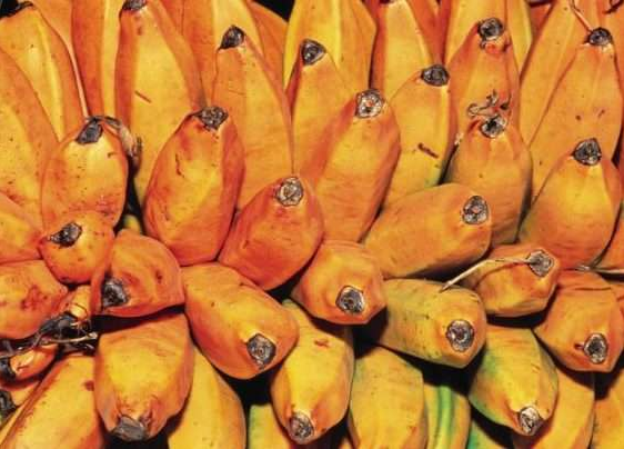

Fei bananas (above) - Maia – and the hua moa banana (in hand)
Hawaii had a huge variety of Polynesian introduced banana and plantain types
https://en.wikipedia.org/wiki/Fe%27i_banana
https://www.moanavoyages.com/en/blog/the-fei-a-typically-polynesian-banana/
https://www.promusa.org/blogpost139-Hawaiian-bananas-then-and-now
Polynesian seafarers introduced bananas to the Hawaiian Islands between 200 and 1350 AD, along with some Fei bananas which constitute a different lineage. All kinds of bananas and plantains (for banana cultivation, see (Kam. 76:37–9)) were introduced. When western culture arrived there were already about 70 different kinds that were known. Today, only about half that number have survived.
These are mainly varieties of Musa xparadisiaca, especially the varieties sapientum and normalis. Some kinds are eaten raw, others cooked. (Neal 245–51) Bananas were taboo to women except certain ones, as maiʻa iho lena and maiʻa pōpō ʻulu, with yellow flesh. Bananas are not mentioned in songs because of unfavorable connotations: see līlā, ʻolohaka. It was considered bad luck to dream of bananas, to meet a man carrying bananas, or to take them in fishing canoes. Polynesians also brought with them a great variety of plants like coconut, turmeric, sugar cane, bamboo, kalo, mountain apple, breadfruit as well as scores of banana varieties.


Breadfruit - ʻulu in Hawaiian. Ulu can be made into "breadfruit poi" that is called poi ʻulu.
https://en.wikipedia.org/wiki/Breadfruit
https://www.bluezones.com/2019/04/what-is-ulu-and-why-should-you-eat-it/
Breadfruit (Artocarpus altilis) is a species of flowering tree in the mulberry and jackfruit family (Moraceae) believed to be a domesticated descendant of Artocarpus camansi originating in New Guinea, the Maluku Islands, and the Philippines. It was initially spread to Oceania via the Austronesian expansion. Breadfruit is propagated mainly by seeds.
Breadfruit is one of the highest-yielding food plants, with a single tree producing up to 200 or more grapefruit-sized fruits per season, requiring limited care. In the South Pacific, the trees yield 50 to 150 fruits per year, usually round, oval or oblong weighing 0.25–6 kilograms (0.55–13.23 lb.) Before being eaten, the fruit are roasted, baked, fried or boiled. When cooked, the taste of moderately ripe breadfruit is described as potato-like, or similar to freshly baked bread.
Trails connected the Ewa Honouliuli Kalo patches feed by Kalo’i gulch stream
Ewa Taro was the best because of the Waianae mountain fresh spring water

Taro (Colocasia esculenta) is a root vegetable. Also called Kalo in Hawaiian
https://en.wikipedia.org/wiki/Taro
It is the most widely cultivated species of several plants in the family Araceae that are used as vegetables for their corms, leaves, stems and petioles. Taro corms are a food staple in African, Oceanic, East Asian, Southeast Asian and South Asian cultures (similar to yams). Taro is believed to be one of the earliest cultivated plants.
‘Ewa was at one time the political center for Oahu chiefs due to its abundant resources that supported the households of the chiefs, particularly the many fishponds around the lochs of Puuloa known today as Pearl Harbor. Ewa was also the second most productive taro cultivation area on Oahu next to Waikiki which had huge inland wetlands (Laimana.)
To the Hawaiian planter kalo was not only the staff of life, it was wealth. The primary item of barter and exchange between relatives, it was also the most prized item when provender was placed on the altars of Lono at the border of each district during the Makahiki festival. Abundance meant plenty of kalo, and plenty of kalo implied ample water supply. (Handy and Handy 1972:313–14)
‘Ewa was known for a special and tasty variety of kalo (taro) called kai which was native to the district. There were four documented varieties; including the Red, White, Dark and Kai koi. (Handy) The poi of kai koi is so delicious.” (Ka Loea Kalai Aina 1899), So famous was the Kai variety that ‘Ewa was sometimes affectionately called Kai o ‘Ewa.
“This district, unlike others of the island, is watered by copious and excellent springs that gush out at the foot of the mountains. From these run streams are sufficient for working sugar-mills. As a consequence of this supply, the district never suffers from drought, and the taro-patches are well supplied with water by the same means.” (Charles Wilkes, 1840-1841, Maly)
One kind of cultural significance a property may possess and that may make it eligible for inclusion in the National Register, is traditional cultural significance. "Traditional" in this context refers to those beliefs, customs, and practices of a living community of people that have been passed down through the generations, usually orally or through practice. The traditional cultural significance of a historic property, then, is significance derived from the role the property plays in a community's historically rooted beliefs, customs, and practices.
Kanehili sinkholes were natural mini-gardens and deep sinkholes with flowing fresh spring were just a gourd scoop away.
Sinkholes in the Ewa Plain area were utilized as natural planters for kalo (taro, dry-land variety), temporary shelters, storage features, and sources of water. The Ancient Kanehili lands were likely to have been planted in ‘ulu (breadfruit), liliko‘i (passion fruit), niu (coconut along the beach areas), and two types of mai‘a (banana). Additionally, birds (today extinct or nearly so) were trapped for feathers.
More contemporary cultural practices taking place in ancient Kanehili included the gathering of ‘uha loa (Waltheria indica) for traditional Hawaiian medicine and ‘alae (red clay) for coloring salt, medicine, dye, and spiritual purification.
Leilono- The Breadfruit Trailway To Heaven (or Hell)
If a soul came to Leilono (Aliamanu crater), there he would find the breadfruit tree of Leiwalo, ka‘ulu o Leiwalo. A soul picking the wrong branch of the breadfruit tree without the help of an aumakua risked falling into hell or purgatory, roaming the plain of Kaupe’a looking in sinkholes for moths or spiders to eat.

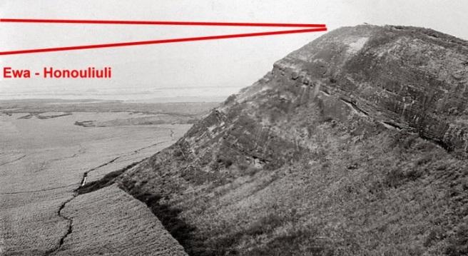
An ancient trail led to the breadfruit tree of Leilono which was said to have been located above Aliamanu. Souls wanting to leap to the Kahiki homeland paradise had to make a critical decision, best done with help of their family aumakua, or risk Hell or a wandering purgatory.
An important Ewa Honouliuli trail led to Leilono (also Leiolono) where a deceased person’s spirit could leap westward into the next world, to the traditional homeland of Kahiki. (Souls “going west” is a worldwide belief from ancient Egyptians to American Indians. In the aviation community, a deceased member is said to have “gone west.”)
If his soul came to Leilono (in Hālawa, ‘Ewa near Red Hill), there he would find the breadfruit tree of Leiwalo, ka‘ulu o Leiwalo. If the soul was not found by an ‘aumakua who knew it (i ma‘a mau iaia), or one who would help it, the soul would leap upon a decayed branch of the breadfruit tree and fall down into endless night, the pō pau ‘ole o Milu. Or, a soul that had no rightful place in the ‘aumakua realm, or who had no relative or friend (makamaka) there “who would watch out for it and welcome it, would slip over the flat lands (of the Ewa Plains) like a wind. (Kamakau 1991b:47).
Leina a ka ‘uhane, National Register TCP Historic District is a suppressed TCP nomination on Oahu by FTA, HART, DLNR-SHPD, HCDA, NAVY, etc
The Night Marchers had their own invisible trails in Ewa
In some cases warriors killed in battle would remain as spirits to march eternally on the ancient Ewa trails. Many stories remain today of reports of residents hearing and seeing the night marchers at certain auspicious times and places in Ewa using ancient trails that can no longer be seen because of development. Some locations, homes and at least one elementary school are known to be haunted.
It is the Hawaiian experience that these trails were, and still remain, important features of the cultural landscape. Even in circumstances where physical remains of the ancient trails have been erased by development and modern land use, it is believed that the po‘e kahiko (ancient people) still walk the land—sometimes in huaka‘i p (processions of night marchers) (Luomala 1983; Interview with Thelma Parish, May 2, 1997, Maly and Maly 2011b:818).
Ewa Honouliuli Native Hawaiian Trails reflect ancient South Pacific Polynesia
And are a rare, unique Traditional Cultural Place (TCP) Landscape on Oahu
Most Hawaii cultural historians believe that the Polynesians who settled Hawaii came from the Marquesas Islands, which had forbidding terrain and poor conditions for farming. Ewa Honouliuli offered large new agricultural spaces fed by spring water and abundant fisheries. Ancient Hawaii was found because of close attention to patterns in ocean currents, large fish schools, celestial observations and annual bird migrations such as the Kolea (Pacific golden plover) that seafaring canoes followed.
When Arriving the new Polynesians found older inhabitants
Around 1000 – 1777 AD: Tahitians from the islands of Ra’iatea, Bora Bora, and Huahine arrived to subjugate earlier Polynesian settlers on Oahu, recreating the earlier Hawaiian culture with their own Tahitian, Raiatean traditions that most people accept today as “traditional” Hawaiian culture. With their larger stature, better social and political organization, they easily overpowered the older islands’ inhabitants on most islands (other than Kauai.) This new Polynesian cultural immigration wave was especially influential in the Ewa Honouliuli area of southern Oahu which provided very abundant resources to support large populations, a political royal hierarchy and Konohiki resource management. Kalo loi on the upland slopes, aquaculture fish ponds in Puuloa (Pearl Harbor) and fresh water springs all over the Ewa Plain (from the Waianae volcano) supported extensive food production agriculture.
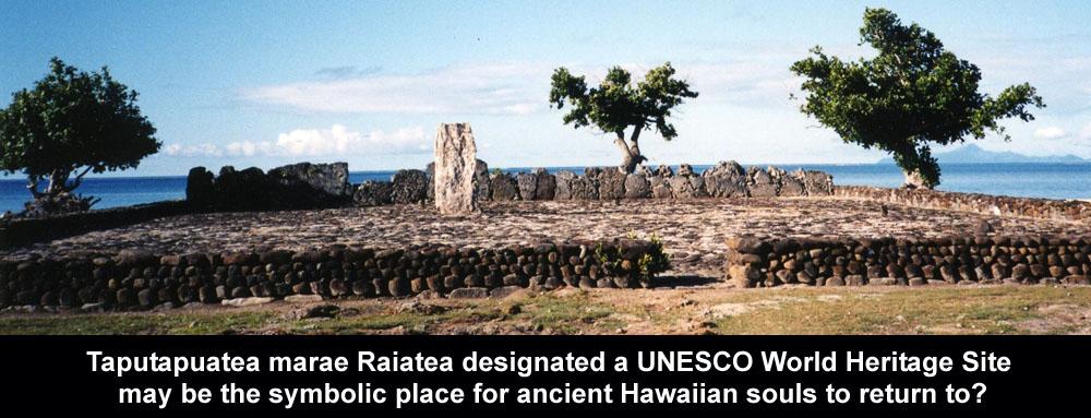
Tahitian Culture Viewpoint: Commoners had chiefly ancestors, but they were commoners because their genealogies had become lost or obscured; thus the flow of chiefly mana was blocked and could not descend to them. This belief formed the rationale for Pa‘ao’s conquest of Hawai‘i. Arriving from Ra‘iatea (then Havai‘i or Havaiki), he found no chiefs eligible to rule. He returned to the South Pacific islands, recruited Pili Ka‘aiea, a prince of the highest bloodlines. With their champions they sailed north and made their conquest, installing Pili Ka‘aiea as the progenitor of the dynasty of ruling chiefs from which Kamehameha I was descended 22 generations later. - Herb Kawainui Käne, The ‘Aumakua —Hawaiian Ancestral Spirits.

Although the Tahitians didn’t slaughter the previous area natives, they reduced them to commoners, calling them Menehune (“people of small status”) and imposed their own elite political system and customs on them. Tahitians had a well-established social and political hierarchy and made extensive refinements in the Konohiki renewable aina (land) resource system where lands were divided up into ahupua’a and managed in great detail for maximum productivity. The Oahu island was called the Mokupuni and was split into several Moku. The Moku (district) parameters ran from the highest mountain top, down to the sea. Chiefs were expected to raise defensive armies and collect taxes.
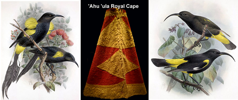
The Kapu system held particular importance. Something which was Kapu was either forbidden or sacred, often due to social rank, gender or seasons. Only nobility could wear feathered garb, such as capes and headdresses. Those making the capes sought feathers from the Mamo and O`o birds which were found in great abundance in ancient Kanehili (MCAS Ewa – NAS Barbers Point.) Nets and traps were used, as well as a sticky sap that could be placed on likely roosts. When a bird landed and got stuck, the bird catcher could pluck the desired feathers, clean the bird's claws, and then release them to grow more feathers as a renewable royal cape resource. Previously birds were simply killed for their feathers.
The early Hawaiian’s saw themselves as land custodians, not land owners
Early Hawaiians didn’t believe land could actually be owned, instead they considered themselves custodians of the aina (earth.) Each of these Mokus were further split into Ahupua’a managed by a Konohiki which was an appointed position. All of these land divisions and management of them required extensive and reliable trail networks that could be used to trade foods, goods and services mauka-makai (mountain to sea) and also provide for a rapid response by the chief’s military forces to any place quickly. In Ewa Honouliuli lookouts based high above the Ewa Plain would immediately dispatch runners down to alert of approaching invasion canoe fleets from other islands (usually Maui or Hawaii islands.)
All of these land divisions and boundaries and the trails that linked them were how taxes were assessed and collected for each area during the annual four month Makahiki period. Two of the most important mauka-makai trails were the Kualaka’i and Oneula. A segment of the Kualaka’i trail can still be seen today which retains its Tahitian style construction attributes and conveys special importance as a ceremonial trail associated with Makahiki, Kahiki homeland and annual Lono processions throughout the ahupua’a.

Kanehili cultural practitioner Michael Lee had royal ancestry and sincerely believed in preserving the ancient cultural landscape history of his ancestors sacred places
The god Lono is associated with fertility, agriculture, rainfall, music and peace. In one of the many Hawaiian stories of Lono, he is a fertility and music god who descended to Earth on a rainbow to marry Laka, a forest goddess. In agricultural and planting traditions, Lono is identified with rain and food plants and was one of the four main revered Hawaiian gods. While Lono stories vary, the Lono that became a revered god on Oahu and ancient Kanehili was likely the legendary Laʻa-mai-Kahiki ("Sacred-one-from-Tahiti), who brought with him a small hand-drum and a flute for the hula. These new flute sounds and drum beat rhythms made a big impression on the native locals in Ewa Honouliuli, making him a celebrity legend in ancient Hawaii and eventually a revered god. (Beckwith 1951, other sources.)
In Lono’s honor and memory, the great annual festival of the Makahiki was held during October through February. War and unnecessary work was kapu (forbidden). Makahiki established community sports, word riddle games, spear-dodging exhibitions and musical dancing entertainment as well as the annual taxation. Using the well maintained commerce and ceremonial trails were also a tax obligation of those residents in the Ewa Honouliuli ahupua’a who contributed labor and construction supplies.
Other esteemed people in the hierarchy system were Kahunas, masters of certain professions such as canoe building, medicine, weather or predicting future events, Kahunas led the others both professionally and spiritually. Often, a particular extended family monopolized a profession, but exceptional skill could gain an outsider admittance as a novice. Kahunas led religious rituals like the annual Lono trail processions to all areas of the ahupua’a and served as spiritual advisors to the head chief.
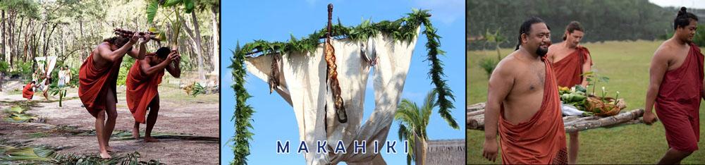
Recent years have seen a revival of celebrating annual Makahiki traditions
Commoners were the working class; farmers, fishermen, artisans, performers, sailors. Because they believed their station in life was natural, they usually harbored no ambition to cross class lines. The Ohana (families) worked their pieces of land, sharing part of their harvests with their host nobles. While this lifestyle bears resemblance to medieval European feudal systems, Ohana’s were not virtual slaves. Because they could go wherever they wanted, the ali’i could not treat them too harshly or they’d take their allegiance elsewhere. An ali’i without sufficient followers would never be able to rise very high through the ranks. However some chiefs could be cruel to common people.
For a number of years after the Tahitians planted their cultural and political roots in Hawaii, travel continued to and from the South Pacific. However, by at least several hundred years before European explorers came, journeying had ended. While the reasons for this cessation aren’t certain, there are several theories including loss of lands and power if one was away for extended periods and a desire to enjoy all of the bounties and benefits of their well-tuned civilization while not wanting to invite any new waves of Polynesian immigrants. And there was already enough competition and strife between islands.
For whatever reason, the Hawaiian Islands became an insular land, with little to no contact with the outside world. In this cultural cocoon, early Hawaiian culture evolved free of external influences, however the arrival of Europeans changed all that. Within 50 years of the introduction of western diseases that the local indigenous natives had no natural immunity to, up to 90% of the Ewa Honouliuli population was dead, leaving unattended empty lands to be eventually taken over by cattle ranchers. Nearly all of the elaborate coral limestone trail structures were reused for cattle fences.
Only in former MCAS Ewa – NAS Barbers Point, the land of ancient Kanehili and the Kualaka’i and Oneula trails, is the historic and cultural evidence still there to be found (and destroyed.) HCDA land developers constantly work to erase the cultural historic features of the past Kanehili historic cultural eras.


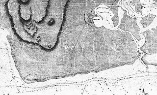
The ahupua’a of Honouliuli, once the most important political, cultural and major native Hawaiian habitation areas on Oahu
NAS Barbers Point has many Traditional Cultural Places (TCP) that are NPS National Register eligible
One kind of cultural significance a property may possess, and that may make it eligible for inclusion in the Register, is traditional cultural significance. "Traditional" in this context refers to those beliefs, customs, and practices of a living community of people that have been passed down through the generations, usually orally or through practice. The traditional cultural significance of a historic property, then, is significance derived from the role the property plays in a community's historically rooted beliefs, customs, and practices.

Sinkholes in the general area were utilized as natural planters for kalo (taro, dry-land variety), temporary shelters, storage features, and sources of water. The Kalaeloa lands were likely to have been planted in ‘ulu (breadfruit), liliko‘i (passion fruit), niu (coconut along the beach area), and two types of mai‘a (banana). Additionally, birds (today extinct or nearly so) were trapped for feathers in or near to the area, including the ae‘o (Himantopus mexicanus knudseni), i‘iwi (Vestiaria coccinea), ‘apapane (Himatione sanguine), and the mamo (Drepanis pacifica).
Honolulu City Council RESOLUTION 12-172, CD1 (2012) passed unanimously:
URGING THE HAWAII COMMUNITY DEVELOPMENT AUTHORITY AND THE STATE OF HAWAII TO RECOGNIZE AND PRESERVE THE HISTORIC TRAILS OF THE EWA PLAINS.
WHEREAS, the trails in the Ewa Plains area later known as Marine Corps Air Station (MCAS) Ewa and Naval Air Station (NAS) Barbers Point, and today called Kalaeloa as administered by the Hawaii Community Development Authority, are part of the greater Ewa Plains of West Oahu; and
WHEREAS, the Ewa Plains is a massive ancient karst coral reef where ocean meets mountain streams and fresh rain water percolates through porous 100,000 year old coral to spawn freshwater shrimp and one of Hawaii’s most diverse limu varieties; and
WHEREAS, these Ewa Plains trails and their adjacent historic sites provide clues as to how communities were linked socially, economically, and politically; which areas were important in early times, places of commerce, and religion; and where valuable forest or sea resources were once located; and
WHEREAS, these Ewa Plains trails were first identified after Western contact by Lieutenant C.R. Maiden of the Royal Navy in 1825 and became known as the Maiden Trails on the first published Oahu maps; and
WHEREAS, these Ewa Plains trails identified by Maiden became used for ranching and horseback transportation and became an indelible part of West Oahu’s 150-year-old Paniolo and Pa’u horseback culture and early Hawaiian Kingdom history of ranches and farms which were the original Western economic settlements of the Ewa Plains; and
WHEREAS, these identified trails became the location where the Ewa Mill and Plantation was established and why the Oahu Railway was extended to this very important trailside agricultural community which allowed sugar cane to become the major economic engine of the Ewa Plains; and
WHEREAS, these Ewa Plains trails in 1925, due to the nearby location of Ewa Mill and the Oahu Railway, became incorporated into the United States (U.S.) Navy development of Ewa Mooring Mast Field as a naval airship mooring site; and
WHEREAS, these trails, springs, and underground karst water transport system later became further documented in State and Federal land surveys and aquifer maps, and in 1941 when the Ewa Mooring Mast Field became a U.S. Marine Corps airbase known as Ewa Field, these walking and horse ranch trails continued to be used by the Marines and Ewa Plantation community for access to the shoreline; and
WHEREAS, after the Japanese air attack on December 7, 1941 and the great expansion of the area into military airports which became MCAS Ewa and NAS Barbers Point during World War II, these trails were important for military training, patrols on foot and mounted Marine Corps horseback security patrols; and
WHEREAS, after the closure of the Marine and Navy airbases, published 1950s maps show the trails on former MCAS Ewa that are still used today by the Barbers Point riding club; and
WHEREAS, these historic horse and foot trails also link with the over 100 year old Oahu Railway right-of-way and Pearl Harbor Historic Trail plan that allows travel by foot, horse or bike from Pearl Harbor to Nanakuli, and which places the Ewa Plains trails as a center junction point and provides access to the Ewa shoreline; and
WHEREAS, an educational feature of these Ewa Plains trails could also be restored karst sinkhole sites along the trailways explaining the ecological system that sustains the iimu, nourishes food sources such as freshwater shrimp and which helps perpetuate Ewa’s offshore fisheries and sustainability; and
WHEREAS, these trails could become a cultural, historic, recreational and educational experience of walking, biking or horseback riding over trails featuring native Hawaiian plants, bird and aquatic life, telling cultural histories, explaining geological facts; and
WHEREAS, an Ewa Plains historic trails project could be a community supported endeavor bringing together cultural practitioners, educators, scientists, environmental and veteran organizations in a positive, holistic concept for community education, recreation and restoration; and
WHEREAS, recreational trails in Ewa could qualify for federal National Park Service (NPS) Recreational Trails Program funding,as well as Surface Transportation Program Flexible, Transportation Enhancement, and Congestion Mitigation Air Quality Improvement Program funding and would be consistent with the Oahu Regional Transportation Plan; and
WHEREAS, federal programs such as the NPS Service Battlefield Protection Program have already awarded a $53,000 grant to help define the Ewa Field battlefield as an historic site, and which could include walking trails and points for historic interpretation; and
WHEREAS, federal programs such as the U.S. Fish & Wildlife Service have programs to restore Ewa Plains karst sinkholes and have already demonstrated that native freshwater shrimp can be restocked and flourish in these unique karst sinkhole habitats, providing working environments for education and training; and
WHEREAS, there are many interested individuals from equestrian clubs, biking, recreational groups, schools, colleges and universities, active duty military family and morale, welfare and recreation organizations, that could benefit from and assist in supporting an Ewa Plains trails program; now, therefore,
BE IT RESOLVED by the Council of the City and County of Honolulu that it supports the mapping and identification of historic trails in the Ewa Plains; and
BE IT FURTHER RESOLVED that the Hawaii Community Development Authority, the State of Hawaii, the United States government, and the City and County of Honolulu are urged to participate in the mapping and identification of the Ewa Plains historic trails; and
BE IT FURTHER RESOLVED that the City and County of Honolulu will not expend any monies to provide for the mapping and
BE IT FINALLY RESOLVED those copies of this Resolution be transmitted to the Hawaii Community Development Authority, the Governor, the Department of Hawaiian Homelands, the Office of Hawaiian Affairs, the President of the United States, the Commander of United States Pacific Command, and the Mayor.
DATE OF INTRODUCTION: 2012 (Passed unanimously 2012)
KANEHILI CULTURAL AND ARCHEOLOGICAL REFERENCES
Draft Final Report Identification of Native Hawaiian Traditional Cultural Properties, Navy Region Hawaii
March 2001 IDENTIFICATION OF NATIVE HAWAIIAN TRADITIONAL CULTURAL PROPERTIES, NAVY REGION HAWAII by H. David Tuggle, Ph.D., M.J. Tomonari-Tuggle, M.A. with the collaboration of Maria E. Ka‘imipono Orr, Kepâ Maly Kumu Pono Associates, and Kalani Flores Mana ‘o‘i‘o. Other input included Marion Kelly, Kawena Johnson and numerous others still living at the time the information was gathered.
1999 Cultural Resource Management Plan: Naval Air Station, Barbers Point. Prepared for Department of the Navy, Pearl Harbor, Hawaii under contract with Belt Collins Hawaii, Honolulu, Hawaii. International Archaeological Research Institute, Inc., Honolulu.
1997 (Tuggle, J.S. Athens, J. Ward, and David Welch) Environment, Vegetation Change, and Early Human Settlement on the ‘Ewa Plain: A Cultural Resource Inventory of Naval Air Station, Barbers Point, O‘ahu, Hawai‘i. Part III: Paleoenvironmental Investigations. Prepared for Belt Collins Hawaii. International Archaeological Research Institute, Inc., Honolulu.
1997 The ‘Ewa Plain. Hawaiian Archaeology 6:8-36.
1997 Synthesis of Cultural Resource Studies of the ‘Ewa Plain, O‘ahu. Prepared for Belt Collins Hawaii and the U.S. Navy. International Archaeological Research Institute, Inc., Honolulu.
1996 (Tuggle, S. Wickler) A Cultural Resource Inventory of Naval Air Station, Barbers Point, O‘ahu, Hawai‘i; Part II: Phase II Inventory Survey of Selected Sites. Task 2b: Archaeological Research Services for the Proposed Cleanup, Disposal and Reuse of Naval Air Station, Barbers Point, O`ahu, Hawai`i . Prepared for Belt Collins Hawaii. International Archaeological Research Institute, Inc.
1996 Cultural Resource Management Plan: Naval Air Station, Barbers Point, O‘ahu, Hawai‘i. Task 3d: Archaeological Research Services for the Proposed Cleanup, Disposal, and Reuse of Naval Air Station, Barbers Point, O‘ahu, Hawai‘i. Prepared for Belt Collins Hawaii. International Archaeological Research Institute, Inc.
1995 Archaeological Inventory Survey for Construction Projects at Naval Air Station, Barbers Point, O`ahu, Hawai`i. Prepared for Belt Collins Hawaii and the U.S. Navy. International Archaeological Research Institute, Inc., Honolulu.
1995 (Tuggle and C. Erkelens) Interpretive Trail Development Study, NAS Barbers Point. Appendix F, in H. David Tuggle, Archaeological Inventory Survey for Construction Projects at Naval Air Station Barbers Point. Prepared for Belt Collins Hawaii. International Archaeological Research Institute, Inc., Honolulu.
1995 A Cultural Resource Inventory of Naval Air Station, Barbers Point, O‘ahu, Hawai‘i: Part I: Phase I Survey and Inventory Summary. Archaeological research services for the proposed cleanup, disposal and reuse of Naval Air Station, Barbers Point, O‘ahu, Hawai‘i (Task 2a). Pre Final report prepared for Belt Collins Hawaii, Honolulu. International Archaeological Research Institute, Inc., Honolulu.
1994 Cultural Resources of Naval Air Station, Barbers Point: Summary, Assessment and Research Design. Prepared for Belt Collins Hawaii and the U.S. Navy. International Archaeological Research Institute, Inc., Honolulu.
1991 Archaeological Survey of Two Demonstration Trails of the Hawaii Statewide Trail and Access System. Prepared for Na Ala Hele Statewide Trails and Access Program, Department of Land and Natural Resources. International Archaeological Research Institute, Inc., Honolulu.
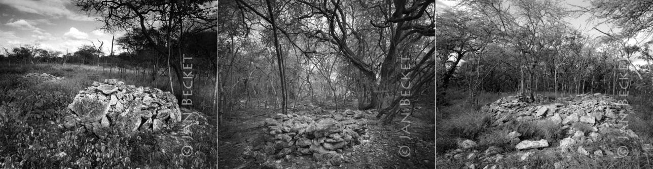
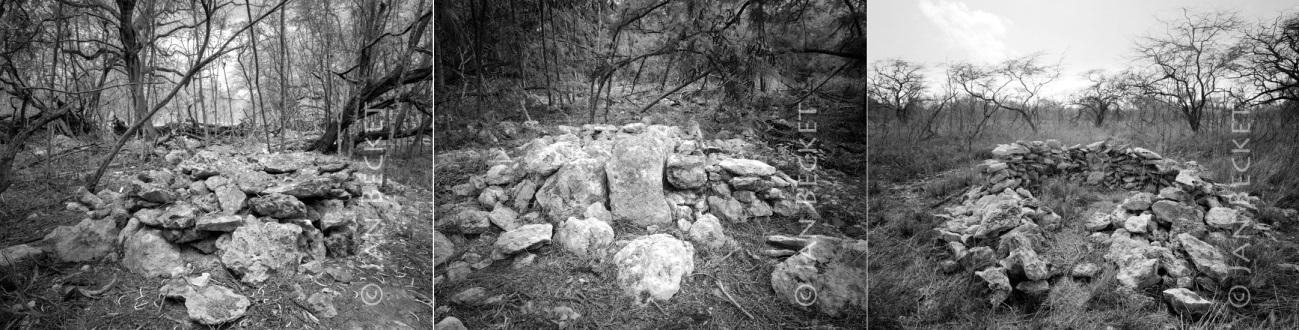
Jan Becket Photos of Ancient Hawaiian Habitation Sites in Kanehili
http://www.janbecket.net/piwigo/index.php?/category/24
http://www.janbecket.net/piwigo/index.php?/category/26
https://janbecket.net/wordpress/?p=1639