Ewa Plains HART Guideway and Stations Intersects with 1825 Malden Trail Survey
By John Bond, Kanehili Cultural Hui

Hawaiian royal cloak in Bishop Museum from 1825 HMS Blonde expedition to Oahu.

Ewa Plain Trails Map by Lt. Malden, Royal Navy

South Oahu Trails Map

Ewa Plain Karst (Ancient Coral Reef)
New AIS Testimony: HART Rail Route Damages
Traditional Hawaiian Cultural Properties
by John Bond, Kanehili Cultural Hui
Numerous groups and organizations submitted comments and testimony on the 22 mile Honolulu Rail Archaeological Impact Statement (AIS) to the State Historic Preservation Division (SHPD) to meet the May 30th Deadline. The new AIS comment period had been extended because of last year's Hawaii Supreme Court ruling that the rail AIS cannot be done in phases or segments.
The previous 2009 AIS omitted a great deal of valid cultural information, many groups were not consulted, and data was skewed to fit a 'rush-to-begin-building-the-rail' agenda, rather than any attempt at honest historic and cultural preservation. The law finally caught up with them.
In his ruling, Federal Judge Wallace Tashima made a special point of noting his concern about the identification of Traditional Cultural Properties (TCPs) along the HART rail route. It was later made clear in recent HART meetings that TCP's include all cultures, not just native Hawaiian, as per federal law.
HART is required to also adhere to Department of Transportation Act of 1966 special provision - Section 4(f) - which stipulates that US DOT agencies-including the Federal Transit Administration (FTA), cannot approve the use of land from wildlife and waterfowl refuges or public or private historical sites unless both of the following conditions apply:
- There is no feasible and prudent alternative.
- The action includes all possible planning to minimize harm to the property resulting from use.
Hawaiian Cultural Practitioner Mike Lee, along with Hawaii Thousand Friends, submitted approximately 800 pages of detailed comment and testimony on the HART Rail AIS covering the entire 22 mile route. This package included maps, photographs, emails with many agencies (HART, SHPD, DLNR, BLNR, Oahu Burial Council, HCDA, etc.) that go back nearly a decade, as well as news articles, historic research and citations, legal documents and filings, native Hawaiian rights, the Clean Water Act, and much more.
A key issue for Lee is the identification of the ancient coral reef limestone along the Oahu shoreline known as Karst, which connects volcanic mountain lava tube water to the shoreline Karst reef water systems. These water springs feed a shoreline ecosystem and was how ancient Hawaiians managed their fish ponds. The Karst was also of very high spiritual importance to ancient Hawaiians and used for sacred burials, such as downtown Honolulu on the grounds of I'olani Palace where there is an ancient Karst burial cave.
"I wanted them to know that I wasn't just making this up ten minutes ago" said Lee. "I am a Konohikist- I believe in the ecological management and protection of our very important natural island water systems. Protecting our Wahi Kapu sites is also very important to me."
Lee's testimony concerns identification and protection of important Hawaiian cultural sites along the rail route, including wahi pana (sacred sites) and wahi kapu (sacred burial areas) and their inclusion into a TCP (Traditional Cultural Properties) that would make sure these special sites, caves, caverns, springs, ponds and water systems are preserved and not contaminated during rail construction.
Also included were photographs of Kawaiaha'o Church which is a graphic example of early Karst limestone block construction. The church and surrounding walls are made of rough ancient reef from the shoreline and ancient sea shells and marine organisms can be clearly seen. The church is also located on the site of an important ancient Karst spring. Nearby I'olani Palace and the royal guard barracks are also constructed from Karst limestone blocks from the shoreline.
In addition, Kanehili Cultural Hui also submitted another approximately 250 pages of detailed comment and testimony on the the HART Rail AIS- primarily concerned with the Honouliuli - Ewa area and the documentation of previously unidentified Traditional Cultural Properties (TCP), Ewa Historic Districts, Ewa Dec 7, 1941 Battlefield Area and an outline for a Honouliuli - Ewa Cultural Landscape Report.
Many current or former Ewa Village residents helped by supplying historic documents, maps, photos and oral histories. The Kanehili Hui name comes from the original Hawaiian name for the Honouliuli - Ewa area and is mentioned by Hawaiian goddess Hi'iaka in her famous and often quoted chants when she traveled through the Ewa Plains area approximately 1000 years ago.
The Kanehili Cultural Hui 501-c-3 non-profit community organization is concerned with the entire cultural history of the area- from ancient times to modern times.
A key focus of the Kanehili Cultural Hui report and testimony was on the 1825 Malden Trails (ancient Hawaiian Trails- believed to have possibly been originally constructed by very early Tahitian arrivals to Kanehili) which played a major role in the Hawaiian cultural history of the Honouliuli-Ewa area, and which was entirely left out of the HART Rail AIS.
The fixed guideway and stations directly overlay the 1825 trails as well as the Kalo'i Karst waterway that flows to the Ewa shoreline.
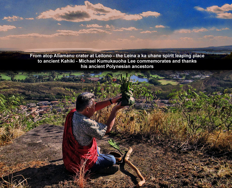
Also of major importance is the identification and location of the Leina a ka Uhane, a sacred spiritual leaping off place for souls returning to the ancient homeland of Tahiti. This is a National Register eligible TCP, yet HART and the SHPD administrator has continuously tried to minimize the importance and geographic area of this TCP as well as apparently intentionally misidentify its location, despite the error being brought to their attention several times since last year.
The previous Rail AIS also failed in many ways to adequately document important Honouliuli - Ewa cultural sites such as the greater Ewa Plantation and railway network that was the largest private railway in Hawaii. The Oahu Railway that served Honouliuli - Ewa plantation railway was chartered under King David Kalakaua.
A Cultural Landscape Report (CLR) is the primary report that documents the history, significance and treatment of a cultural landscape. A CLR evaluates the history and integrity of the landscape including any changes to its geographical context, features, materials, and use.


***********************************************************
Honolulu City Council RESOLUTION 12-172, CD1 (2012) passed unanimously:
URGING THE HAWAII COMMUNITY DEVELOPMENT AUTHORITY AND THE STATE OF HAWAII TO RECOGNIZE AND PRESERVE THE HISTORIC TRAILS OF THE EWA PLAINS
WHEREAS, the trails in the Ewa Plains area later known as Marine Corps Air Station (MCAS) Ewa and Naval Air Station (NAS) Barbers Point, and today called Kalaeloa as administered by the Hawaii Community Development Authority, are part of the greater Ewa Plains of West Oahu; and
WHEREAS, the Ewa Plains is a massive ancient karst coral reef where ocean meets mountain streams and fresh rain water percolates through porous 100,000 year old coral to spawn freshwater shrimp and one of Hawaii’s most diverse limu varieties; and
WHEREAS, these Ewa Plains trails and their adjacent historic sites provide clues as to how communities were linked socially, economically, and politically; which areas were important in early times, places of commerce, and religion; and where valuable forest or sea resources were once located; and
WHEREAS, these Ewa Plains trails were first identified after Western contact by Lieutenant C.R. Maiden of the Royal Navy in 1825 and became known as the Maiden Trails on the first published Oahu maps; and
WHEREAS, these Ewa Plains trails identified by Maiden became used for ranching and horseback transportation and became an indelible part of West Oahu’s 150 year old Paniolo and Pa’u horseback culture and early Hawaiian Kingdom history of ranches and farms which were the original Western economic settlements of the Ewa Plains; and
WHEREAS, these identified trails became the location where the Ewa Mill and Plantation was established and why the Oahu Railway was extended to this very important trailside agricultural community which allowed sugar cane to become the major economic engine of the Ewa Plains; and
WHEREAS, these Ewa Plains trails in 1925, due to the nearby location of Ewa Mill and the Oahu Railway, became incorporated into the United States (U.S.) Navy development of Ewa Mooring Mast Field as a naval airship mooring site; and
WHEREAS, these trails, springs, and underground karst water transport system later became further documented in State and Federal land surveys and aquifer maps, and in 1941 when the Ewa Mooring Mast Field became a U.S. Marine Corps airbase known as Ewa Field, these walking and horse ranch trails continued to be used by the Marines and Ewa Plantation community for access to the shoreline; and
WHEREAS, after the Japanese air attack on December 7, 1941 and the great expansion of the area into military airports which became MCAS Ewa and NAS Barbers Point during World War II, these trails were important for military training, patrols on foot and mounted Marine Corps horseback security patrols; and
WHEREAS, after the closure of the Marine and Navy airbases, published I 950s maps show the trails on former MCAS Ewa that are still used today by the Barbers Point riding club; and
WHEREAS, these historic horse and foot trails also link with the over 100 year old Oahu Railway right-of-way and Pearl Harbor Historic Trail plan that allows travel by foot, horse or bike from Pearl Harbor to Nanakuli, and which places the Ewa Plains trails as a center junction point and provides access to the Ewa shoreline; and
WHEREAS, an educational feature of these Ewa Plains trails could also be restored karst sinkhole sites along the trailways explaining the ecological system that sustains the iimu, nourishes food sources such as freshwater shrimp and which helps perpetuate Ewa’s offshore fisheries and sustainability; and
WHEREAS, these trails’ could become a cultural, historic, recreational and educational experience of walking, biking or horseback riding over trails featuring native Hawaiian plants, bird and aquatic life, telling cultural histories, explaining geological facts; and
WHEREAS, an Ewa Plains historic trails project could be a community supported endeavor bringing together cultural practitioners, educators, scientists, environmental and veteran organizations in a positive, holistic concept for community education, recreation and restoration; and
WHEREAS, recreational trails in Ewa could qualify for federal National Park Service (NPS) Recreational Trails Program funding,as well as Surface Transportation Program Flexible, Transportation Enhancement, and Congestion Mitigation Air Quality Improvement Program funding and would be consistent with the Oahu Regional Transportation Plan; and
WHEREAS, federal programs such as the NPS Service Battlefield Protection Program have already awarded a $53,000 grant to help define the Ewa Field battlefield as an historic site, and which could include walking trails and points for historic interpretation; and
WHEREAS, federal programs such as the U.S. Fish & Wildlife Service have programs to restore Ewa Plains karst sinkholes and have already demonstrated that native freshwater shrimp can be restocked and flourish in these unique karst sinkhole habitats, providing working environments for education and training; and
WHEREAS, there are many interested individuals from equestrian clubs, biking, recreational groups, schools, colleges and universities, active duty military family and morale, welfare and recreation organizations, that could benefit from and assist in supporting an Ewa Plains trails program; now, therefore,
BE IT RESOLVED by the Council of the City and County of Honolulu that it supports the mapping and identification of historic trails in the Ewa Plains; and
BE IT FURTHER RESOLVED that the Hawaii Community Development Authority, the State of Hawaii, the United States government, and the City and County of Honolulu are urged to participate in the mapping and identification of the Ewa Plains historic trails; and
BE IT FURTHER RESOLVED that the City and County of Honolulu will not expend any monies to provide for the mapping and
BE IT FINALLY RESOLVED that copies of this Resolution be transmitted to the Hawaii Community Development Authority, the Governor, the Department of Hawaiian Homelands, the Office of Hawaiian Affairs, the President of the United States, the Commander of United States Pacific Command, and the Mayor.
DATE OF INTRODUCTION: 2012 (Passed unanimously 2012)
##############################################################